Peaks Island Shoreline Stabilization Project
Introduction
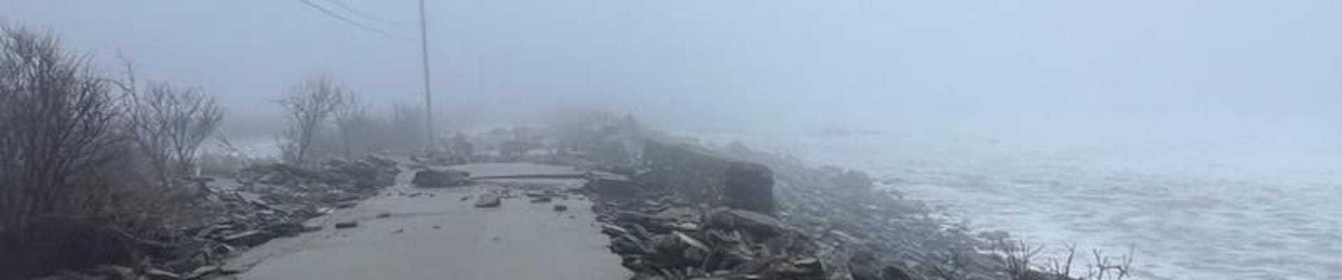
The Peaks Island Seashore project is a FEMA authorized repair project under Disaster Declaration 4764-DR-ME, established in response to severe storm surge and surface flooding between January 9 and January 13, 2024.
Project Goals and Funding
The primary objectives are to protect existing public infrastructure, stabilize the eroding shoreline, and repair damaged roadways. The project is supported by $6,009,458 in FEMA/MEMA/City funding. The funding match is a 75/15/10 split, where FEMA contributes 75%, MEMA contributes 15%, and the City contributes 10%. This includes $5,235,295 dedicated to repairing infrastructure back to its pre-storm state and $774,163 allocated for mitigation measures future storm events.
Scope of Work
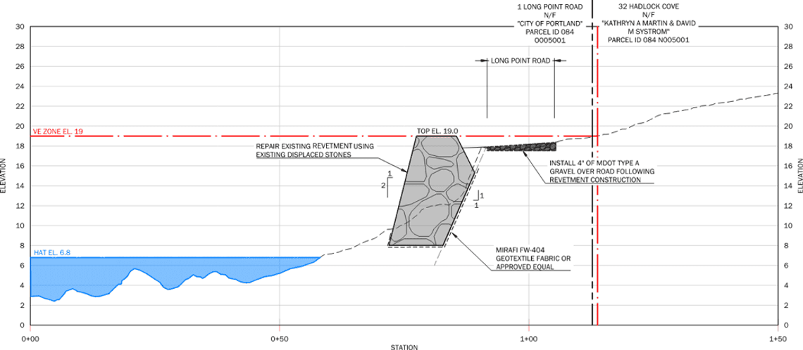
Long Point Road: This area will be restored to its pre-storm condition. The work includes repairing the existing riprap revetment, replanting lost native vegetation, and fixing the gravel roadway surface.
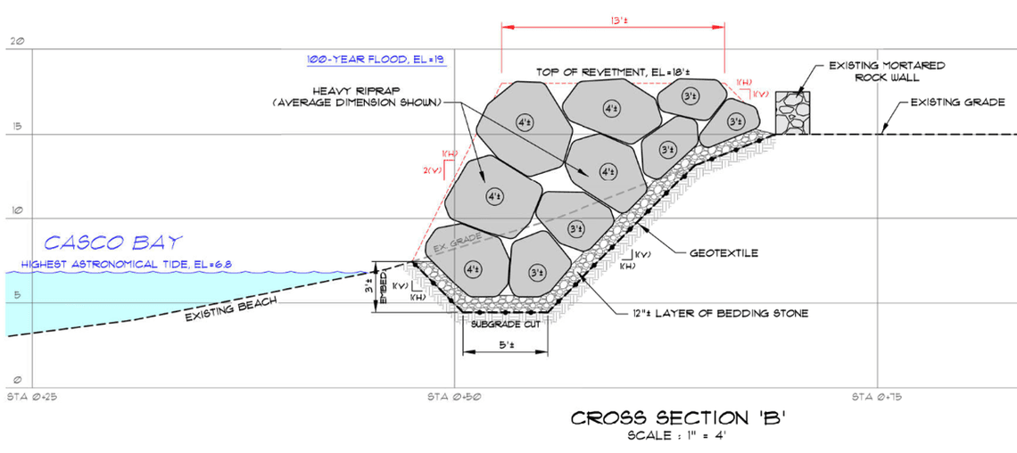
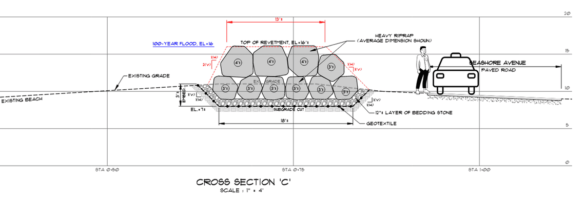
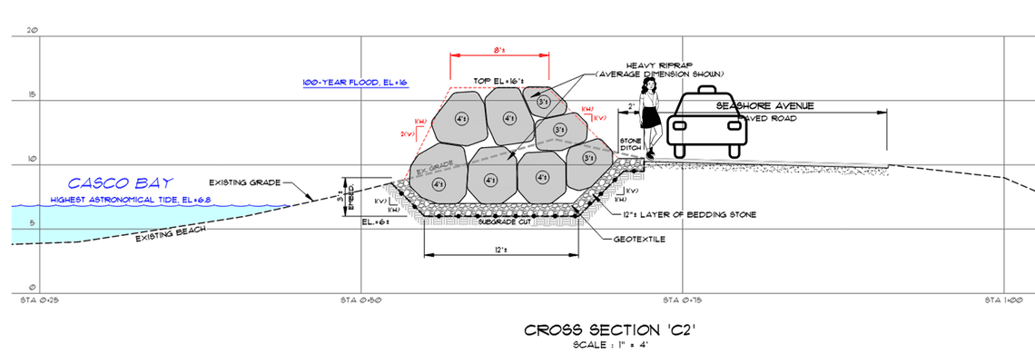
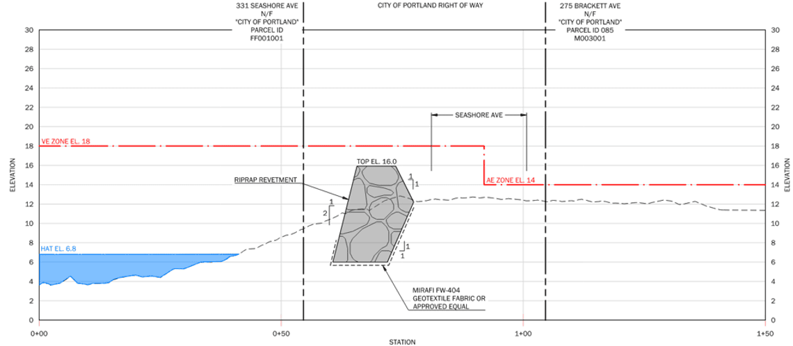
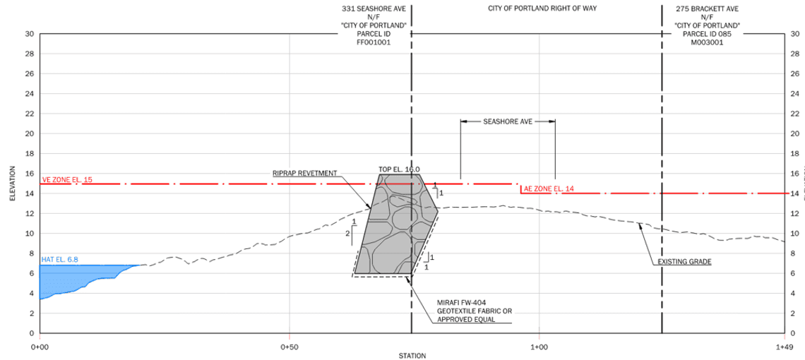
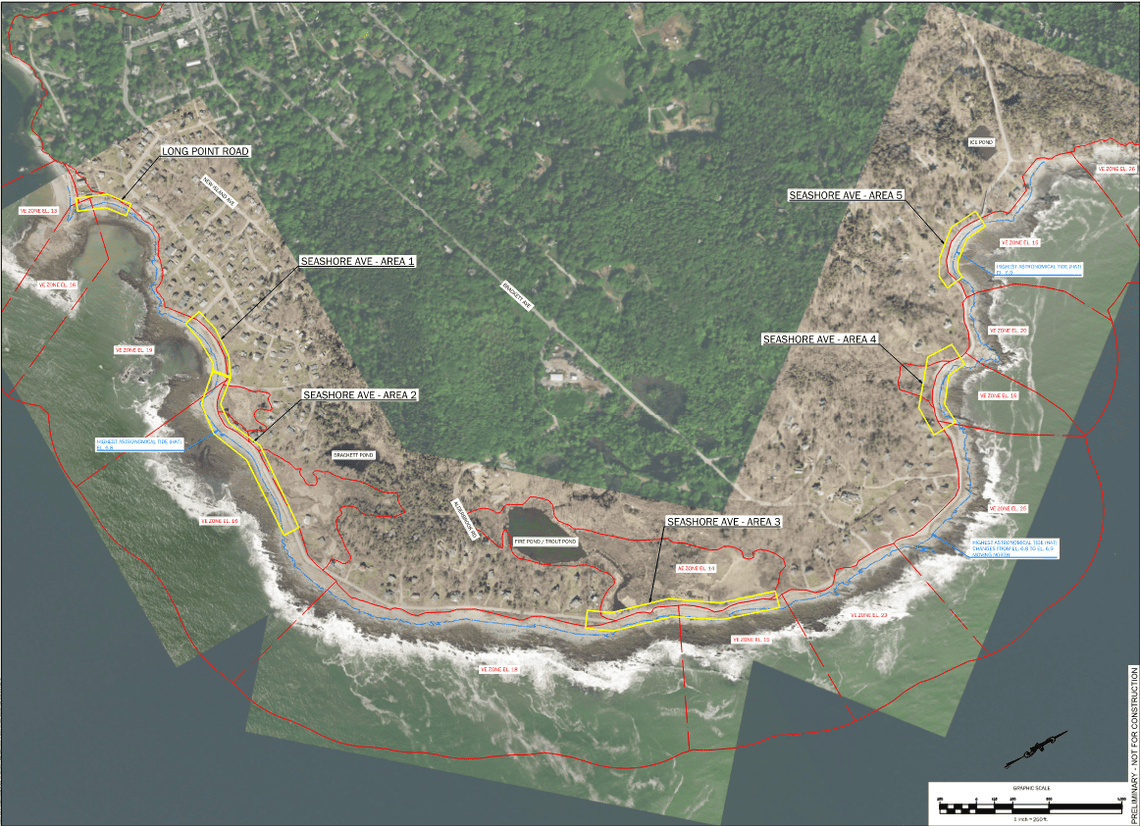
Seashore Avenue: The project targets five specific locations along this road for both repair and mitigation as identified by FEMA. Improvements include installing adequately sized riprap revetments built relative to base flood elevations. The project will also repair the damaged roadway and resolve existing drainage issues in these areas.
Basis of Design
- Limited to the areas and repair methods identified by FEMA
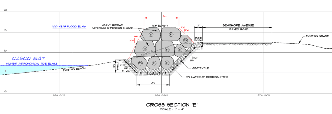
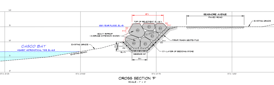
- Revetment was chosen instead of living shorelines because this is a high wave energy environment
a. Riprap sizing calculations show that 4+ foot diameter rock is required to withstand wave energy and buoyancy
1. 4 to 5 foot diameter rock = 8,000 to 16,000 pounds - Height of revetment
a. Designed revetment top elevation to meet base flood elevation (100-year storm) where feasible - Spatial constraints for design:
a. Limited to the area owned by the City of Portland/within the City’s ROW
b. Limited to the area between the high tide line and the roadway - Budget constraints
a. Design a project that is likely to meet the FEMA allocated budget (not exceed)
Frequently Asked Questions
(This will be updated and revised as additional questions on the project come in)
Question: Where can I find project design plans?
Answer: These will be posted to this webpage in early November 2026
Question: How were the project areas determined?
Answer: FEMA and MEMA representatives evaluated the damage from the January 2024 storms and created a DDD (Damage, Description and Dimensions) of the areas that were impacted by the storms which formed the basis of the repairs to the damaged areas for the project.
Question: Why is this funding being used for this project and not for other projects on Peaks Island?
Answer: The City of Portland received funding from FEMA for repair and mitigation for these specific areas that were identified by FEMA as being damaged from the January 2024 storms.
Question: Is this design finalized? (October 2026)
Answer: The design has not been finalized and is actively being worked on.
Question: When is this project expected to be bid/constructed?
Answer: Project is anticipating bidding this winter, with construction occuring 2027.
Question: How was the height of the revetment determined?
Answer: Designed revetment top elevation to meet base flood elevation (100-year storm) where feasible
Question: How high will the Riprap extend above the roadway?
Answer: Height of revetment in the current design above the roadway is as follows:
Long Point Road (~150 FT long): ranges from 0 to 2.5 feet above the roadway elevation
Seashore Avenue Area 1 (~475 FT long): ranges from 0 to 4 feet above the roadway elevation
Seashore Avenue Area 2 (~1,175 FT long): ranges from 1 to 6 feet above the roadway elevation
~250 feet of this is 5 to 6 feet above the road, in the area of the intersection of Seashore Avenue and Great Pond Road
Seashore Avenue Area 3 (~1,300 FT long): ranges from 0 to 3.5 feet above the roadway elevation
Seashore Avenue Area 4 (~450 FT long): ranges from 0 to 3.5 feet above the roadway elevation
Seashore Avenue Area 5 (~550 FT long): ranges from 0 to 2 feet above the roadway elevation
Question: How will this project affect the access to the beach?
Answer: The public can access the beach along Seashore area in all non-project areas, and on either side of the proposed riprap revetment sections.
Question: Will parking be affected along Seashore Ave?
Answer: There may be parking impacts during construction, but no impacts to parking that are anticipated as part of this project post construction.
Question: Why was a living shoreline approach not used for the design of the shoreline?
Answer: Revetment was chosen instead of living shorelines because this is a high wave energy environment
Question: What is the FEMA deadline for this project?
Answer: The FEMA deadline for construction is 12/31/2027
Question: Amount of FEMA funding and City budget being allocated for proposed Peaks Island project?
Answer: The breakdown for funding that has been allocated for this project are as follows - $6,009,458 total funding
FEMA share (75%): $4,507,094.12
MEMA (state) share (15%): $901,418.80
City share (10%): $ 600,945.88
Question & Answers
Please use the below link to submit questions you have regarding the project We will endeavor to respond to the questions submitted here prior to the November 2026 Peaks Island Council Meeting
Project Timeline
Storm Damage
FEMA/MEMA Site visits and damage evaluation
Project Location Map
Peaks Island Project Locations
Preliminary Design Cross Sections