

Neighborhood Traffic Calming Program
Creating safer streets is a shared priority in Lake Stevens, and traffic calming is a critical part of that effort. Traffic calming utilizes engineered solutions to lower vehicle speeds and promote more mindful driving behavior. Whether through speed cushions, curb extensions, or other targeted measures, these improvements prioritize the safety and wellbeing of all road users while encouraging a community-first approach to traffic management.
Lake Stevens is dedicated to incorporating community perspectives and empowering residents to contribute to decisions that will impact their neighborhoods and daily travels. Together, we can achieve streets that are safe, efficient, and accessible for all.
We are working on launching an official Neighborhood Traffic Calming Program and need your input! Sign up for updates below to be notified of engagement opportunities including a survey and public meeting, or share your thoughts directly with the Public Works team via the portal.
What's the best way to submit your concerns? Submit a service request using the portal below:
https://lakestevens-service-request-lakestevens.hub.arcgis.com/
Want to learn more? Check out our Local Road Safety Plan by clicking the attached document on the right side of this page.
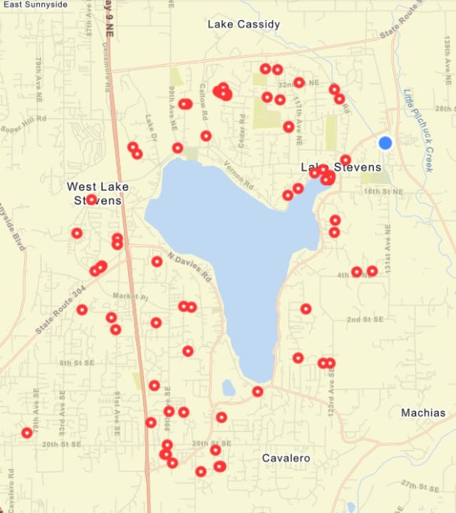
Traffic Calming Request Map
As of August 2026, these are the current requests in the queue to be evaluated. The red dots represent locations of reported vehicle speeding received through the city's request portal. Residents can add locations to the map by using the link above.
Traffic Speed and Volume Data Map
Public Works conducts routine traffic speed and volume studies throughout the city and publishes the data on a public-facing GIS map. Traffic study reports can be viewed at the link below.
Stay Informed
Get notified on upcoming engagements and the latest project related news.
Timeline
This project has multiple phases including development of a policy, public outreach, and stakeholder coordination, that will help guide the development of the final program/toolkit.