
Consultation results
Find out what you told us on the heatmaps and our proposed steps to help with these issues.
Armley, Bramley & Stanningley, Kirkstall
Consultation results
The Leeds Streets for All heatmap consultation for Armley, Bramley & Stanningley, and Kirkstall was live from 6 November to 17 December 2023.
Over 235 people dropped 616 pins on the five different maps, telling us about the travel issues they face in the wards of Armley, Bramley & Stanningley, and Kirkstall. Analysis of the text box comments showed a total of 897 issues spoken about by residents.
Comments by ward
Comments were divided by the three wards as follows:
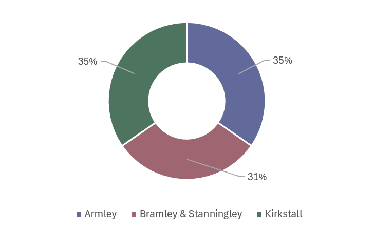
- Armley - 35%
- Bramley & Stanningley - 31%
- Kirkstall - 35%
*percentages may not add up to 100 due to rounding.
Comments by theme
Respondents were able to comment on five themes focusing around travel. Comments were divided by the five themes as follows:
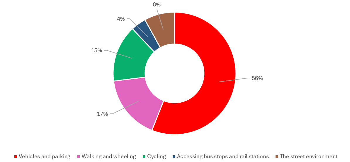
- Vehicles and parking - 56%
- Walking and wheeling (including accessibility) - 17%
- Cycling - 15%
- Accessing bus stops and rail stations - 4%
- Street environment - 8%
*percentages may not add up to 100 due to rounding.
Interactive data map
We've recorded all of the comments made on the five maps so that you can see all the information in one place.
Embed
Most popular issues highlighted:
| Vehicles and parking | Walking and wheeling | Cycling | Accessing bus stops and rail stations | Street environment |
|
|
|
|
|
Suggested solutions from the Leeds Streets for All consultation
Feedback from this consultation has enabled us to identify potential solutions to your issues related to travel and safety. These are plotted by theme on the map below – you can click on any of the icons for more information.
We will prioritise these solutions when bidding for external funding from regional and national sources. Then, when funds become available we will undertake further public consultation, with more detailed designs. If you have any other queries regarding this please contact us on connectingleeds@leeds.gov.uk.
Embed
Discover more

Comment on accessing bus stops and rail stations
Tell us about issues with accessing bus stops and rail stations in your area.

Comment on vehicles and parking
Tell us about issues with vehicles and parking in your area.

Comment on the street environment
Tell us about issues with the street environment in your area.
Comment on walking and wheeling
This includes accessibility, prams, wheelchairs, scooters. Tell us about issues with walking and wheeling in your area.

Comment on cycling
Tell us about issues with cycling in your area.
Stay Informed
Follow our projects to get notified of upcoming engagements and the latest project related news.