

Transport and Connectivity Supporting Paper
This is a HTML friendly version of the transport and connectivity supporting paper.
Leeds Local Plan
Transport and Connectivity Supporting Paper
Why is the policy needed?
Leeds has an ambition to be a city where you don’t need a car to meet your everyday needs, where everyone has access to an affordable and accessible zero carbon choice in how they travel. Historically, Leeds has been described as a motorway city which can be seen in the road network surrounding our district, our lack of a mass transit system and the fact that the majority of people still prefer to drive to work than use public transport or other sustainable modes of transport.
Recent changes to the National Planning Policy Framework (NPPF) state that transport issues should be considered from the earliest stages of plan-making and development proposals, using a vision-led approach to identify transport solutions that deliver well-designed, sustainable and popular places. This work involves ensuring patterns of movement, streets, parking and other transport considerations are integral to the design of schemes and through identifying and pursuing opportunities to promote walking, cycling and public transport use. As such, planning policies should provide for attractive and well-designed walking and cycling networks, as well as providing for any large-scale transport facilities – such as public transport projects.
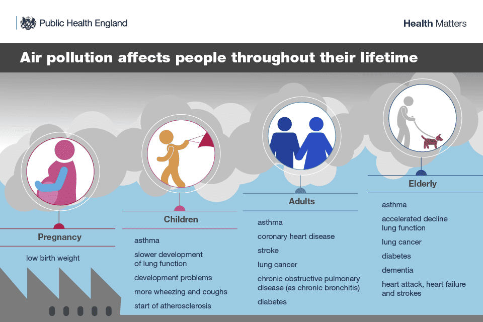
Whilst driving is a preferable option for many reasons, it also has significant implications on our built and natural environment as well as everyone’s health, particularly the most vulnerable members of society. Official statistics, published in 2023, by the Department for Transport (DFT) indicates that within the UK, cars produce 57% of transport emissions, with Leeds being the local authority with the highest greenhouse gas emissions from transport. The government Office for Health Improvement & Disparities (2022) states that the pollutants from vehicle (and industrial) processes fills the air we breathe with greenhouses gases and pollutants that directly impact human health. In the UK, air pollution is responsible for an estimated 28,000 to 36,000 excess deaths a year. In Leeds, it is estimated that at least 5.7% of deaths each year in Leeds can be linked to air pollution. The main mode of travelling to work in Leeds has been by cars for every year since 2012 with latest figures showing 43.3% of the population of Leeds travels to work by car. Despite this, cars and light vans each year spend, on average, 96% of their time parked either at home or at another destination. Therefore, it can be concluded that our city’s preference for car travel is both harmful to the planet and our health.
One of the objectives of the National Design Guide is to create well-located, high quality and attractive public spaces. The National Design Guide states that in these well-designed places, streets are public spaces which are open to all, and they encourage people to walk and cycling rather than to depend on cars. This does not mean that cars cannot be present in our society, it just means that they do not dominant our spaces.
The Local Plan will seek to address some of the environmental impact of transport by trying to ensure that new development occurs in sustainable locations. This would mean that new housing, employment land, etc., would happen along key public transport corridors, or within an accessible walking / wheeling distance to other services you may wish to access on a daily basis. This will increase the likelihood that more people will prefer to use sustainable modes of transport as their first choice, as it will be more accessible to them. Additionally, research suggests that the design and layout of new development has a significant impact on people’s transport preferences. If people live or work in an area where it is not pleasant to walk, wheel, cycle or use public transport then they will not do so. Therefore, the Local Plan needs to influence the design and layout of new developments to encourage a modal shift to more sustainable transport.
If we get this right, we will see levels of air pollution shrink in Leeds, giving us and future generations cleaner air to breathe. If we dedicate less space to cars, we will have more space for the things local people want to see in their community – more green space, more places for their children to play, more local shops, etc.,
What is it seeking to achieve?
Planning is but one piece of the puzzle of making Leeds a city where you don’t need a car to meet your everyday needs. One of the strategic objectives of the Local Plan is to locate development in sustainable locations. Through the development of the Local Plan, this will be partially achieved through the allocated of land where it is considered sustainable to develop.
Another mechanism by which the Local Plan can support the ambition for Leeds to be a city where you don’t need to own a car to meet your everyday needs is through the development of planning policies related to transport. As previously stated, and as this report will continue to advocate; the design and layout of new developments has essentially ‘locked’ the people of Leeds into car dependency, because the alternatives are just not an attractive and viable option for many people.
Therefore, planning polices could seek to mandate that all new developments are designed through a ‘vision-led’ approach, where sustainable transport is designed into schemes from the first point of development. There are many cities where this has been achieved, and subsequent guidance has been produced to demonstrate best practice.
We believe that these policies will provide the Council with the relevant tools to be able to negotiate better transport options for the people of Leeds. This will result in an environment where less space is dedicated to cars, where sustainable transport is the first, most affordable and accessible option for everyone and where the city and its people are healthier.
Is it justified by the evidence?
The travel to work survey is an annual survey conducted by Connecting Leeds that helps to identify commuting trends and to inform future transport investment decisions. The 2024 survey ran between 6th March and 5th April 2024 (returning to its former spring period), with 5,073 individual responses received. The survey is sent to numerous registered public and private businesses in Leeds, asking individuals how many days they commute to work and their primary method of commuting to work for each day of the week.
The main mode of travelling to work in Leeds has been by cars for every year since 2012, with very little change between 2011 and 2017, with a small gradual decrease between 2017 and 2019, a sharp decrease in 2020 (related to Covid-19) and remaining at a lower proportion since and with a small gradual decrease being seen once again at a similar rate pre-2019. Sustainable transport modes have remained relatively consistent between 2011 and 2019, with decreases apparent in 2020 (more so for bus and rail) and with gradual increases seen since in recent years. The decreases for all these transport modes from 2019 levels have been a result of the surge in ‘other’ modes, mainly working from home, which has a slight decrease in the last period.
There has been an 11% increase in the proportion of travel to work trips made by sustainable transport modes in 2024 compared to 2022, with a 2% decrease in the proportion of trips made by cars and motorcycles in the same time frame, indicating an overall shift towards sustainable travel modes. However, the longer term shows a decrease of 35% in sustainable travel modes in the last five years (2020-24) compared to the five years prior (2015-19), with a smaller 22% decrease in the proportion of trips by private car/motorcycles. However, this reflects the shift towards working from home in recent years which would involve no travel rather than a fundamentally negative trend in terms of sustainable travel, hence a grey shading being used in this instance.
The Royal Town Planning Institute (RTPI) published its fourth instalment of the Location of Development report in November 2024. The report explores housing developments that were granted planning permission over the period 2012-2021 to compare the extent they might deliver better access to a range of key destinations that represent local services and community facilities. The report shows that accessibility of approved new homes remained broadly constantly over the study period, meaning there was no improvement in access to key destinations. Furthermore, there was little to no improvement in the take up of public transport over the option of driving to local facilities from newly approved homes. Cars were 1.5 faster nationally to reach key destinations from residential developments. The relationship between settlement patterns, urban form and sustainability is important because these relationships can promote preference for sustainable transport, thus reducing car dependence and overall transport emissions. Developments which are designed to be inclusive of public and active modes of transport (as well as other design elements such as compact, medium density and mixed-use schemes, which will be addressed through other policies in the Local Plan) can encourage continued physical activity, economic participation and social interaction for an ageing population.
The New Economics Foundation published a report in 2024 which argues that the design and layout of new housing developments has increasingly encouraged car-dependent lifestyles. The report stresses that the ingrained design of cars into new developments goes against the globally important challenges of climate and biodiversity breakdown, to poor health driven by environmental pollution and travel patterns, to inequalities in access to services and economic, social and cultural opportunities. New housing development streets and roads are typically designed around cars first and foremost, with much of the common space being used for driving or parking and streets often laid out in a maze-like pattern of cul-de-sacs. This can reduce the financial viability of bus routes and car-centric street designs can make the physical environment less pleasant and safe for active travel. The report recommends that local authorities should determine their own policies relating to integrating sustainable transport into new developments.
The updated NPPF calls for transport to take a ‘vision-led approach’. In light of this, the report published by Create Streets and Sustrans in 2024 provides an insightful perspective into how we can achieve this. The report argues that transport planning has been dominated by the ‘predict and provide’ model, which predicts the inevitable growth of car ownership - everyone will drive everywhere, and so more roads are needed to meet that demand. The problem with this model is that it results in new developments which are designed around the car as the main mode of transport, essentially ‘locking in’ the need for driving. The report recommends multiple design changes to new development – higher, gentle density, reducing parking requirements, developing more public space etc and investing in active travel and public transport., The authors stress that these changes would result in a less space intensive development which offers people a genuine choice in sustainable transport.
In 2019, Leeds City Council and Leeds Beckett University carried out consultation to establish an overall view and understanding of physical activity across Leeds. This study revealed that almost 98% of people want to be physically active, but they feel that there is nothing to currently motivate them to do so. The study also revealed our environment needs to make it easier for people to be physically active, this could include things such as making the physical environment more appealing to increase the design to be there and be active. Additionally, improvements to sustainable transport infrastructure, such as better public transport links and better maintained walking / cycling infrastructure.
How will it help us deliver our corporate strategy?
The Best City Ambition is our overall vision for the future of Leeds and is built upon three pillars: health and wellbeing, inclusive growth and zero carbon. At its heart is our mission to tackle poverty and inequality and improve quality of life for everyone who calls Leeds home. This policy approach directly supports all three pillars of the best city ambition.
The pillar of Health and Wellbeing strives for Leeds to: “be a healthy and caring city for everyone: where those who are most likely to experience poverty improve their mental and physical health the fastest, with health and care inequalities reducing, and people being supported to thrive from early years to later life.”. Active travel and public transport are both mechanisms for achieving a healthy city which prioritises wellbeing. Both these modes of transport and better for the environment as they reduce the environmental impact of private car travel. Further, active travel (as the name suggests) involves an element of physical activity. Physical activity has many benefits for both an individual’s physical and mental health.
Relating to the pillar of zero carbon, pillar there is a need to focus on “Delivering a low-carbon and affordable transport network which encourages people to be physically active and reduces reliance on the private car, helping people to get around the city easily and safely”. Safe and easy walking and cycling and access to Public Transport and shared mobility alternatives offer an important (and lower carbon) alternative to the private car.
Finally, with regards to the pillar of inclusive growth, “Leeds will be a place where we create growth in our economy that works for everyone, where people and businesses can thrive, and we work together to tackle poverty and inequality.” Car dependency can exacerbate inequalities for those less likely or unable to drive such as women, people of colour, young adults, disabled people and those with low or no incomes. These groups are less likely to own or use cars but are more likely to feel the impact of traffic related air pollution, or narrow footpaths. Further, more deprived communities are more likely to live in areas dominated by traffic, impacting air quality and making active travel and unpleasant experience. By designing new development around sustainable transport and moving away from car-centric design we are supporting the ambition of inclusive growth by reducing the harmful impacts of car travel on those already experiencing inequality.
Finally, it is the Council’s ambition for Leeds to be a city where you don’t need a car to meet your everyday needs, where everyone has an affordable and accessible zero carbon choice in how they travel. This means where walking and cycling are the first and easy choice for short journeys, with a fully integrated low carbon transport network, with decreased car dependence, and with a “go anywhere” active and public transport network. A new approach to how transport is integrated into new developments across Leeds will work towards the Connecting Leeds transport ambitions.
How is it consistent with the National Planning Policy Framework?
The NPPF states that transport issues should be considered from the earliest stages of plan-making and development proposals, using a vision-led approach to identify transport solutions that deliver well-designed, sustainable and popular places. This work involves ensuring patterns of movement, streets, parking and other transport considerations are integral to the design of schemes and through identifying and pursuing opportunities to promote walking, cycling and public transport use. As such, planning policies should provide for attractive and well-designed walking and cycling networks, as well as providing for any large scale transport facilities – such as public transport projects.
The new approach we are proposing directly aligns with the transport ambitions of the NPPF by ensuring that new development is designed to successfully integrate active travel and public transport as well as reducing car dependency across Leeds.
How are we going to measure the impact?
The success of this policy will be assessed via the annual Leeds Travel to Work and Travel to School surveys.
Whilst the availability of public transport and active travel networks will not directly impact the changes in travel behaviour, they will contribute towards them.
How will it be implemented?
The policy will be implemented through the Development Management process and used in the determination of planning applications affecting all development across Leeds.
This policy will have an important role in clearly setting out what the expectations of new development are.
Further guidance is offered in supplementary planning documents and the Leeds Design Code.
Equality, diversity, cohesion and inclusion
As previously stated, car dependency can exacerbate inequalities for those less likely or unable to drive such as women, people of colour, young adults, disabled people and those with low or no incomes. These demographics are less likely to own or use cars but are more likely to feel the impact of traffic related air pollution, or narrow footpaths. Further, more deprived communities are more likely to live in areas dominated by traffic, impacting air quality and making active travel and unpleasant experience. A policy seeking to ensure that new development is successfully integrating sustainable transport solutions is predicted to have a positive overall effect on the protected characteristics (age, disability, gender reassignment, marriage and civil partnership, pregnancy and maternity, race, religion or belief, sex, and sexual orientation).
Lorry Layovers
Why is the policy needed?
Lorry layovers are crucial parts of transport infrastructure to ensure that HGV drivers can receive an opportunity to rest to comply with driving hours regulations, preventing fatigue and ensuring safety for all road users. They are also required for loading/unloading goods, or to manage unexpected delays. The National Planning Policy Framework states that planning policies should help to create the conditions in which businesses can invest, expand and adapt. As such, policies should pay regard to facilitating development to meet the needs of a modern economy, including by identifying suitable locations for uses such as laboratories, gigafactories, data centres, digital infrastructure, freight and logistics. Lorry layover facilities form an integral part of these businesses to ensure the safe moving of goods and services.
Leeds is a good location for lorry layover sites as Yorkshire is situated in the middle of Britain, making it a convenient location for drivers travelling across the from Scotland to London/SE and vice versa, thus complying with driving hours regulations. Driving hours are a significant factor in determining the location of layover parking and this needs to be balance in demand and load/driver security.
Is it justified by evidence?
A recent report “Lorry Parking Demand Assessment” (LPDA) was published by National Highways. September 2023. This sets out an assessment of lorry parking demand on or close to the Strategic Road Network (SRN).
Having enough lorry parking and rest areas near the SRN (within approximately 5 kilometres) is important for National Highways to meet three main goals: Safety, Customer Service, and Delivery.
Local authorities need support to help ensure that lorry parking demand is met by safe, secure and comfortable facilities. Local Planning Authorities (LPAs) are tasked with the responsibility of aligning land-use planning with economic needs and are directly responsible for approving applications for new lorry parks. Therefore, it is essential for them to have a straightforward means of evaluating lorry parking demand in their respective areas. The evidence provided in the data assessment in LPDA is considered most suitable to develop the LPDA at the LPA level. The data derived from DfT Lorry Parking Survey, supplemented by the analysis conducted in the report, facilitates this process.
The approach provides a score for offsite and on site parking issues with office calculated with number of lorries parked per km. Local Authorities with the highest number of lorries parked per km score 10, while the onse with the least scored 0.1. Like the off-site analysis, a comparable quantitative method was used to assess local authorities based on the severity of their parking issues at lorry parks. The average utilisation of all lorry parks within each authority was calculated and scored accordingly. Local authorities where the highest average utilisation rates were found were given a score closer to 10, while those with lower utilisation rates were assigned scores closer to 0.
The final score was on a scale of 0 to 20, with up to 10 points allotted for off-site parking issues and up to 10 points for on-site lorry park utilisation issues. A local authority scoring 20 indicates critical Page 31 of 53 lorry parking issues, necessitating immediate support and attention. On the other hand, a score nearer 0 implies negligible issues. Leeds Scores 9.
It's important to consider local geographies when assessing the need for lorry parking facilities. For instance, the A1(M) (to the south of North Yorkshire) does not face as severe lorry parking issues compared to nearby areas like Leeds and Wakefield. However, a closer look reveals that the sections of the A1(M) (west of Selby) experience high lorry parking utilisation and HGV flows, indicating a need for improved lorry parking provisions in this area. The region in shown in Figure 6-5. This section of the A1(M) in North Yorkshire is at the centre of regional distribution. It connects major areas such as Leeds, Wakefield, Selby, North Lincolnshire, Bradford, Huddersfield, York, and Doncaster, all of which are significant operating centres and freight generators. Despite running through North Yorkshire, sections of the A1(M) are as close to Leeds city centre as they are to Selby. Therefore, it is essential to consider the influence and freight needs of Leeds when planning lorry parking facilities on this part of the SRN; parts of North Yorkshire, Leeds and Wakefield are under the same unofficial freight boundary. The analysis should also consider local freight routes and National Highways' Route Strategies (discussed later in this report). The evaluation should aim to identify any influences on the A1(M) from neighbouring roads such as the M62, M180, and A64. It's noteworthy that the A1(M) in North Yorkshire is only approximately 2 miles north of the point where the M62 and A1(M) intersect in Wakefield. So it is important to recognise cross-boundary issues. Even though Selby (North Yorkshire) does not have a particularly high lorry parking score, as neighbouring authority Wakefield does experience high lorry parking demand, constructing a lorry park on the A1(M) in North Yorkshire could potentially alleviate some of the issues and consequently reduce Wakefield's unmet demand. In summary, Leeds, Wakefield, and North Yorkshire received varying scores in the analysis. Nevertheless, it's crucial to recognise that the combined urban areas of Selby, Leeds, and Wakefield fall within the same freight catchment area. This collective perspective should be considered when making decisions about new or improved facilities that extend beyond the local authority level.
Mass Transit and Railway Infrastructure
Why is the policy needed?
Significant investment in transport infrastructure in Leeds is proposed over the coming years. The Connecting Leeds Transport Strategy[1] and West Yorkshire Transport Strategy 2040[2] provides the framework for many of these proposals, most of which lie outside of the remit of the planning system. They recognise how major investment in transport infrastructure has supported the development, growth and success of the city we have today. Leeds, however, like any successful city, is restricted in the amount that it can grow by a lack of transport capacity. To accommodate growth in travel and population, whilst simultaneously addressing the climate emergency and ensuring inclusivity, we need to deliver higher capacity modes of public transport that keep the city moving.
A series of rail construction and upgrade schemes, which will have an important role in enhancing our intercity connections, are being planned at a national level through the Integrated Rail Plan for the North and Midlands[3]. This includes proposals for Northern Powerhouse Rail and TransPennine upgrades which will directly affect Leeds, as well as a commitment to undertaking a study to look at how to bring HS2 trains from the East Midlands to Leeds. The Connecting Leeds Transport Strategy recognises the importance of the rail network to Leeds, and its ‘Enhance public transport’ big move includes a commitment to working with partners to secure the investment needed to deliver transformational improvements to the rail network. Improvements to railway infrastructure will help to increase their capacity and improve the speed and reliability of services, providing greater opportunity for people to travel by sustainable modes.
The Connecting Leeds Transport Strategy also recognises the importance of the development of mass transit in Leeds. Mass transit is a crucial missing element of our transport infrastructure and will fill the gap in public transport provision between bus services and heavy rail. It will add capacity to the key corridors within the city region, making it easier for more people to access more jobs, and get to where they need to go, by sustainable modes of transport. In doing this, it holds significant potential to boost productivity, enable inclusive growth and tackle the climate emergency.
Plans for a new West Yorkshire Mass Transit network are being developed by the West Yorkshire Combined Authority. Their draft Connectivity Infrastructure Plan[4] plans for a modern, integrated transport system for West Yorkshire, with the delivery of mass transit being one of four key priorities. The accompanying draft Mass Transit Vision 2040[5] sets out how mass transit has the potential to re-shape local transport networks around high-quality, high-capacity public transport. A national commitment to the West Yorkshire Mass Transit scheme, and to supporting WYCA in advancing these proposals, was provided by the Government through the Integrated Rail Plan.
WYCAS Mass Transit Vision 2040 sets out the intention that the West Yorkshire Mass Transit will have nine lines[6] in total, forming a network of route that spans West Yorkshire and integrates with the wider rail and bus works to significantly enhance connectivity across the sub-region. It recognises that the delivery of the whole network will take time, and will be delivered over phases, with Leeds City Centre (as the most travelled area in West Yorkshire) being at the heart of the system and being served by the early phases.
Public consultation on route options for the first phase took place between July and September 2024. This focussed on options for the:
- ‘Leeds Line’ that connects St James Hospital and the White Rose via Leeds City centre (with potential for further onward connection to Dewsbury through a later phase)
- ‘Bradford Line’ that connects Leeds City Centre and Bradford City Centre.
It is vital that a joined-up approach is taken in planning for, and responding to, these significant transport investments. Whilst many aspects of these (and other) transport related proposals lie outside of the remit of the spatial planning system, it is essential that there is alignment between spatial and transport planning, and that wherever possible opportunities to support transport policy proposals through spatial planning (and vice versa) are taken.
At present, Spatial Policy 11 of the Core Strategy provides very high level support for mass transit and new railway infrastructure. It sets out 11 transport infrastructure investment priorities for Leeds, of which (i) includes “Public transport improvements for the bus and rail networks (including supporting the role of Leeds City Station, enhancing Leeds’ role as a regional transport hub, and new rail stations were appropriate) and investment in a rapid transit system to increase radial route capacity to the City and Town Centres and to improve reliability together with investment in the provision of Park and Ride Facilities”. The Key Diagram also shows the former NGT, High Speed Rail and proposed railway electrification routes.
A new policy on mass transit and rail infrastructure is needed to more specifically help support the delivery of the West Yorkshire Mass Transit network in Leeds, and ensure that proposals related to both Mass Transit and the upgrading of railway infrastructure realise the potential they hold to deliver a range of social, economic and environmental benefits. This will have an important role in helping to tackle the climate emergency, supporting the city’s transition towards carbon neutrality and realising the 43% reduction in CO2 emissions from transport by 2030 sought by the Connecting Leeds Transport Strategy.
What is the policy seeking to achieve?
The policy is seeking to create a framework that;
- Facilitates the development of mass transit network in Leeds; providing clarity that support should be given to related schemes, and ensure that emerging mass transit routes benefit from protection from any proposals that may prejudice its implementation;
- Ensures that mass transit and railway networks are positively integrated into existing and proposed development; and
- Establishes the key principles that Leeds City Council expects mass transit or rail infrastructure proposals to meet
This will help to support the delivery of these crucial elements of transport infrastructure, and ensure that they come forward in a manner which maximises the potential benefits they offer, and minimises or mitigates any potential adverse impacts (from a economic, environmental and social perspective).
Is the policy justified by the evidence?
Yes. The policy provides clear support for a new mass transit network, which has been identified as a key local, sub-regional and national priority (as outlined above). The draft WYCA Mass Transit Vision specifically notes the opportunity this presents to deliver improved connections along nine potential route corridors. Six of these include land within Leeds; East Leeds, Leeds – Bradford, South Leeds – Dewsbury, Bradford & North West Leeds, Wakefield and Five Towns and North Leeds.
It is proposed that the principles and expectations set out in the policy will draw on (particularly the NPPF, PPG and National Design Guide) and the lessons learned through work undertaken to plan for integration of the previously proposed HS2 line into the City, and through the former Supertram and NGT mass transit proposals. It is proposed that this would includes principles relating to regeneration and place-making, green and blue infrastructure, permeability across the route corridors, heritage assets and flood risk.
How will the policy help deliver the Council’s corporate strategy?
Through its support for mass transit and improvements to railway infrastructure, this planning policy would directly supports the zero carbon pillar of the Leeds Best City Ambition[7]. The Best City Ambition recognises that, as part of this, there is a need to focus on “Delivering a low-carbon and affordable transport network which encourages people to be physically active and reduces reliance on the private car, helping people to get around the city easily and safely”. Mass Transit and rail both offer an important (and lower carbon) alternative to the private car, particularly for longer journeys that cannot be made by walking or cycling. The policy also responds to the climate change challenge recognised through the Ambition, and the need to “Ensure a public transport system that is safe, active, accessible, clear and energy-efficient to help people get around the city”.
How is the policy consistent with the NPPF?
The NPPF makes a number of references to the role that the planning system has relation to transport. Of particular relevance to this proposed policy, this includes:
- Para 20(b): Strategic policies should set out an overall strategy for the pattern, scale and design quality of places, and make sufficient provision for…infrastructure for transport…”
- Para 104: “Transport issues should be considered from the earliest stages of plan-making and development proposals, so that…
(b) opportunities from existing or proposed transport infrastructure, and changing transport technology and usage, are realised…; and
(d) the environmental impacts of traffic and transport infrastructure can be identified, assessed and taken into account – including appropriate opportunities for avoiding and mitigating any adverse effects, and for net environmental gains”
- Para 106: “Planning policies should:
(c) identify and protect, where there is robust evidence, sites and routes which could be critical in developing infrastructure to widen transport choice and realise opportunities for large scale development; and
(e) provide for any large scale transport facilities that need to be located in the area [including public transport projects] and the infrastructure and wider development required to support their operation, expansion and contribution to the wider economy…”
The policy would directly respond to these elements of national planning policy, making provision for the new transport infrastructure that is anticipated over the coming years. The requirements of the policy would seek to ensure that the benefits of these schemes are maximised, and any potential adverse impacts are minimised or mitigated as far as possible. The policy would also seek to provide protection from proposals that would prejudice the delivery of mass transit.
How will it be implemented?
The planning system will have an important role in helping to facilitate the delivery of mass transit and upgrades to the rail network. Where proposals require planning consent, and permission for this is sought through the ‘usual’ planning application process under the Town and Country Planning Act, the policy will be implemented through the Development Management process. Plans, projects or development proposals associated with the delivery of mass transit, rail infrastructure improvements, or which could have implications for the above (by virtue of them either presenting a threat to the implementation of mass transit, or there being an opportunity to design them in such a way so they are well integrated with the mass transit or rail networks) would need to satisfy the requirements set out in the policy. In accordance with planning law, applications will be determined in accordance with the development plan, unless material considerations indicate otherwise.
It is necessary, however, to recognise that some elements of the works involved will be likely to follow different consenting processes. In particular, orders are likely to be made by the Secretary of State for Transport under the Transport and Works Act 1992 (the TWA) to authorise new railway or tramway schemes (such as mass transit). TWA Orders can authorise a wide range of matters, including the power to construct, alter, maintained and operate a transport system, compulsory powers to buy land, and the closure or alterations or roads and footpaths. As part of this process, applicants can also ask the Secretary of State for Transport to grant planning permission for the development described in the order. As part of this, consideration will be made of how the proposals align with strategic plans such as the Local Plan.
In the case of rail proposals, railway undertakers also benefit from deemed consent (‘permitted development’) for certain types of works to railway infrastructure. This means that they may not need to submit a planning application for certain types of works. In such cases, there would be no legal obligation to take the requirements of this policy into account.
There are, however, likely to be opportunities, through any discussions that may take place between the City Council, WYCA and Network Rail (or any other involved parties) about intended proposals, and through the more formalised consenting process under the TWA, to signpost to this policy. In this way, it can be used to support any negotiations that may take place and help to influence proposals even where compliance with the policy may not strictly be required as a matter of law.
Equality, diversity, cohesion and integration
The delivery of mass transit and rail infrastructure improvement projects offer potential benefits from an equality, cohesion and integration perspective, with the improved accessibility brought about by these schemes enabling people to more easily access a wider range of jobs, facilities and services without the need for a car. This is likely to be of benefit to all people, including those with protected characteristics.
Whilst exact Mass Transit routes have not yet been agreed, it is proposed that they will travel through and connect some of the most deprived areas of Leeds. Recognising this, and the potential that this type of infrastructure investment can have, the policy also specifically seeks to ensure that schemes are holistically designed to ensure that their potential to stimulate investment and regeneration is maximised. This is important from an equality perspective, helping to ensure that the positive impacts of mass transit (in particular) extend beyond accessibility, and support investment in, and the wider regeneration of, the places along its routes.
Leeds Station
Why is a policy needed?
The railway network is very important for Leeds’ economy, and in the decarbonising of transport. Over the next two decades passenger numbers at Leeds Station are set to increase significantly as more people choose to travel by more sustainable forms of transport. In order to accommodate this, significant investment and development is going to be required.
The Connecting Leeds Transport Strategy[8] provides the framework for transport investment in Leeds. It sets a vision for Leeds to be a city where you don’t need a car, and where everyone has an affordable and accessible zero carbon choice in how they travel. It establishes six ‘big moves’ that will help achieve this ambition, and the target of reducing CO2 emissions from transport by up to 43% by 2030. The ‘Transform the City Centre’ big move recognises the importance of Leeds station in providing a gateway to Leeds via the national rail network, and identifies the need to support Leeds City Station, enhancing its role as a regional transport hub and enabling the integration of high speed rail. The Strategy sets the target for 100% increase in rail travel by 2030.
An Integrated Rail Plan for the North and Midlands[9] (IRP) was published by the Government on 18th November 2021. This commits funding to deliver a number of key rail programmes, as part of the TransPennine Route Upgrade and Northern Powerhouse Rail. Capacity improvements on the network at Leeds Station will be required to accommodate these, including platform extensions. These works will increase services into the station, and also enable it to be served by longer trains, and therefore increase passengers numbers.
In October 2020 planning permission was granted[10] for various improvements and alterations to the station forming delivery of the first phase of the Leeds Integrated Station Masterplan (LISM)[11]. This enables the creation of a fully accessible multi-modal transport hub, with free-flowing pedestrian movement out of the station to the city centre and wider city areas. It involves various improvements to the arrival space to the front of the station, which reduces the flow of vehicular traffic, improves connectivity and creates a safer and more welcoming environment for pedestrians and cyclists using the station and adjacent streets. It also includes the creation of a new purpose-built taxi shelter, and environmental enhancements to the area under the Neville Street Bridge, along Dark Neville Street and Little Neville Street to make these places feel safer and more attractive for users. Work has also recently been completed to remodel the track layout between platforms 4 and 6, and to create a new Platform Zero, to help reduce train congestion and disruption to services. A series of further applications and developments are expected over the coming years to deliver further improvements to the station and its infrastructure.
Leeds Station is currently mentioned a number of times across existing policy documents (including the Core Strategy, Site Allocations Plan and Aire Valley Leeds AAP, and the South Bank Leeds Regeneration Framework SPD). In particular, Policy SP11 of the Core Strategy recognises its important role as a regional transport hub and provides support to proposals that would enhance this. However, there is no currently specific policy to guide the future development of the station.
The development of the station will be phased over a number of years to ensure that the station can continue to function throughout the construction work. As a result, it will be particularly important to ensure that all proposals work together to respond to the various opportunities and challenges that the redevelopment of Leeds Station presents. It is considered that a new policy is needed to bridge this gap, giving additional weight to the key design / planning principles that should underpin development proposals, and ensure the full potential that the redevelopment of the station presents is realised.
What would a policy be seeking to achieve?
The proposed policy would set out requirements for development of, in and around Leeds Station. This would ensure that all proposals work to deliver the same vision, and address both the opportunities and challenges presented by the development of the station.
It is likely that the requirements identified in the policy could build on principles, opportunities or expectations that were established through the Leeds Integrated Station Masterplan (LISM), which was developed alongside the South Bank Leeds Regeneration Framework SPD and HS2 Growth Strategy. By incorporating them into planning policy they would have additional weight in the decision making process and ensure that all proposals are assessed against the same requirements.
Is a policy justified by the evidence?
Yes. As noted above, it is likely that many of the requirements in the policy could build on principles established through the Leeds Integrated Station Masterplan (LISM) and the South Bank Leeds Regeneration SPD. LISM was developed to help ensure that all of the different phases of development work together to respond to all the various opportunities and challenges that the redevelopment of Leeds Station presents. It sets out a holistic and phased development strategy for the station and the surrounding roads, places and spaces. It aims to improve the experience of everyone using the station by increasing pedestrian capacity, supporting the regeneration of the South Bank, and incorporating future rail upgrades. The South Bank Leeds Regeneration Framework SPD builds upon this masterplan, providing future guidance on its principles and how it relates to the wider regeneration plans for the South Bank.
Both LISM and the South Bank Leeds Regeneration Framework SPD were prepared on the expectation that Phase 2 of HS2 would extend into Leeds. A new station, which would lie to the south of the existing station, was planned to accommodate this, and LISM (and consequently the South Bank SPD) considered how the two elements of the station would be integrated and respond to their surroundings. Whilst the Government’s Integrated Rail Plan no longer proposes that Phase 2 of HS2 will include a link to Leeds, it does commit to further work being undertaken to look at the most effective way to run HS2 trains to Leeds and it confirms that the safeguarding of land for rail use including the HS2 station will not be lifted while this further work is undertaken. Whilst this may have implications for the timing and delivery of the southern extension to the station that had been proposed, the headline principles on which the masterplan and SPD are based (and which have fed into the policy) remain central to our ambitions for the station and would likely continue to provide a sound basis for this planning policy.
How will the policy help deliver the Council’s corporate strategy?
Through its support for the development of Leeds Station, this proposed planning policy directly supports the zero carbon and inclusive growth pillars of the Leeds Best City Ambition[12]. The Best City Ambition recognises that as part of the zero carbon pillar there is a need to focus on “Delivering a low-carbon and affordable transport network which encourages people to be physically active and reduces reliance on the private car, helping people to get around the city easily and safely”. Our railways offer an important (and lower carbon) alternative to the private car, particularly for longer journeys that cannot be made by walking or cycling. Similarly, in relation to the ‘Inclusive Growth’ pillar, it is acknowledged that “place matters and positive identity, culture, heritage and pride in our communities are vital assets in a sustainable future for the City and its local centres”. In seeking to ensure that development at the station is of the highest design quality, and that the Station provides a welcoming (and fitting) entrance to the City, the policy will help support this pillar.
The proposed policy also responds to the climate change challenge recognised through the Ambition, and in particular the need to “Ensure a public transport system that is safe, active, accessible, clear and energy-efficient to help people get around the city”.
How is the policy consistent with the NPPF?
The NPPF makes a number of references to the role that the planning system has in relation to transport infrastructure. Of particular relevance to this proposed policy, this includes:
- Para 104: “Transport issues should be considered from the earliest stages of plan-making and development proposals, so that…
(b) opportunities from existing or proposed transport infrastructure, and changing transport technology and usage, are realised…; and
- Para 106: “Planning policies should:
(e) provide for any large scale transport facilities that need to be located in the area and the infrastructure and wider development required to support their operation, expansion and contribution to the wider economy…”
This policy would directly respond to these elements of national policy, recognising the need for development at Leeds Station and supporting its continued operation and (potential) future expansion.
How will it be implemented?
The policy would be implemented through the Development Management process, and used in the determination of planning applications affecting Leeds Station. This includes proposals for the development of the station itself, as well as schemes around the station that may have implications for the requirements set out in the policy (i.e. proposals for places such as City Square and Princes Square that may impact on the setting of the station, or access to it, where consideration will also be need of how they may affect the delivery of the vision for the station itself).
Network Rail (as a railway undertaker) also benefits from deemed consent (‘permitted development’) for certain types of works to railway infrastructure, including railway stations. This means that they may not need to submit a planning application for certain types of works. In such cases, there would be no legal obligation to take the requirements of this policy into account. However, it is expected that this policy will have an important role in clearly setting out what the expectations of Leeds City Council are for proposals related to Leeds Station. This can be taken into account when schemes are developed, and can be signposted to and used to support any negotiations that may take place, and help to influence proposals even where compliance with the policy may not strictly be required as a matter of law.
Equality, diversity, cohesion and integration
When developing detailed proposals for development in and around the station it will be vital that accessibility for all users is ensured. This is consistent with all other forms of development. Existing policies and legislation (including through building regulations) will apply and ensure that the particular access requirements of some of those with protected characteristics – including those with disabilities or older persons – are addressed. Therefore, it is likely that the works to the station supported through the Policy (particularly those relating to improved access) will have positive outcomes from an equality perspective.
In addition, the policy seeks improvements to some of the key public spaces around the station, including the Dark Arches and the railway arches to the south of Trevelyan Square. It is recognised that the lighting and low levels of activity in these areas currently means that they may not be perceived as welcoming spaces, particularly at night-time. Whilst this is an issue for all, the perception of risk may be particularly felt by those who are (or feel) more vulnerable as a result of their age, disability, sex, sexual orientation, race, religion or belief. As a result, improvements to these spaces may also deliver positive outcomes from an equality perspective.
[1] https://www.leeds.gov.uk/parking-roads-and-travel/connecting-leeds-and-transforming-travel/transport-policy
[6] East Leeds, Bradford-Leeds, South Leeds-Dewsbury, Bradford-Dewsbury, Huddersfield-Dewsbury, Bradford-Halifax, Wakefield & Five Towns, Bradford & North West Leeds, and North Leeds.
[8] https://www.leeds.gov.uk/parking-roads-and-travel/connecting-leeds-and-transforming-travel/transport-policy
[10] Application reference no. 20/02048/FU
Discover more
Statement of Representation
Providing details about the purpose of the consultation, how to view the material, how to submit comments, accessibility and privacy notice.
Archived 2025 Consultation Material
This is for information only

Further information
Explains the work already undertaken on the Plan and the new plan-making process
Leeds Local Plan Issues & Options Consultation Report
Summary of the Leeds Local Plan Issues & Options Consultation Summer 2025

Leeds Local Plan Scoping Consultation Document
We would like your views on which general topic areas the Leeds Local Plan should cover and how you would like to be consulted as the plan is developed.
Stay Informed
Follow our projects to get notified of upcoming engagements and the latest project related news.