
Second consultation - Results
Find out the results of the second consultation and the next steps
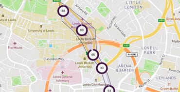
Woodhouse Lane Gateway
Consultation results
Thank you to everyone that provided feedback on the second round of consultation for Woodhouse Lane. The consultation ran from Wednesday 6th November to Monday 16th December 2024 and received 693 responses.
Your feedback is important to us and helps to shape the proposals, alongside other information including traffic, pedestrian and cycling counts, bus delay data, and road safety information. We also consider proposals in line with our Vision Zero and Connecting Leeds Transport Strategy aims.
We have reviewed and analysed all the responses and, together with the other factors listed above, have subsequently made some changes to the scheme. These are summarised at the bottom of this page.
Below are the main findings from feedback received from online surveys, paper surveys at events, postal surveys and emails.
How do you feel about our proposals overall?
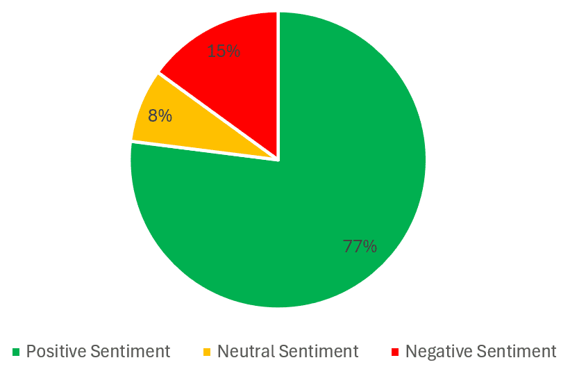
77% of respondents were positive or mostly positive regarding the proposals overall. 15% were negative or mostly negative and 8% were neutral.
Free text comments
Analysing the 177 free text comments, the most common themes were:
- Cycling infrastructure: many respondents appreciated the improvements the proposals would make, including segregated cycle lanes and better connectivity. However, there were concerns about the safety of cyclists, especially at crossings and bus stops.
- Public transport: several comments highlighted the need for better bus services and more reliable public transport. Respondents mentioned that the current bus services are poor and need improvement to complement the proposed road changes.
- Pedestrian safety: there was significant support for improving pedestrian safety, with suggestions to prioritise pedestrian crossings and make the area more walkable. Some respondents also mentioned the need for better pathways and crossings for wheelchair users.
- Environmental concerns: many respondents supported the idea of making the area greener and more environmentally friendly. They suggested adding more trees, greenery, and reducing pollution.
- Accessibility issues: several comments raised concerns about the impact of the proposed changes on people with disabilities and those who rely on cars for transportation. There were suggestions to ensure blue badge parking remains and to consider the needs of less-mobile citizens.
- Traffic congestion: some respondents were worried that the proposed changes would increase traffic congestion and travel times for motorists. They mentioned that reducing road space for cars could lead to more pollution and longer journeys.
- Impact on businesses: a few comments expressed concerns about the negative impact on local businesses due to reduced vehicular access and parking. They mentioned that businesses might suffer if customers find it difficult to reach them.
- General support: despite the concerns, there was overall support for the proposed changes, with many respondents appreciating the efforts to improve the area and make it safer and more pleasant for pedestrians and cyclists.
Other comments included:
- Desire for gaps in cycle track to allow access to and from St Mark’s Street and St Mark's Avenue for cycles
- Desire for St Mark’s Road to be closed completely
- Concern about restrictions on movements into and out of St Mark’s Road
- Concern that proposals will result in more traffic in residential areas
- Concern that the inbound bus stop near Notre Dame Sixth Form College will still be too busy and create challenges for inbound cycles
Do you feel the proposals will help meet the scheme objectives?
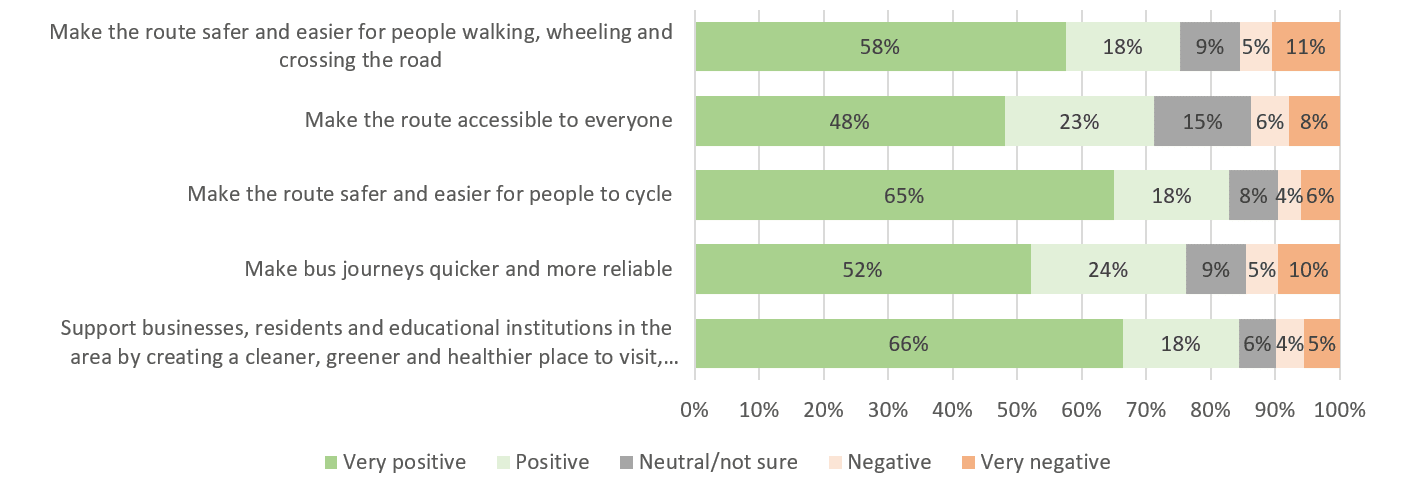
The chart shows whether respondents agreed or disagreed as to whether the proposals would help to meet the scheme's objectives.
Over 70% of respondents agreed that the proposals would:
- make the route safer and easier for people walking, wheeling and crossing the road (76%)
- make the route accessible to everyone (71%)
- make the route safer and easier for people to cycle (83%)
- make bus journeys quicker and more reliable (76%)
- support businesses, residents and educational institutions in the area by creating a cleaner, greener and healthier place to visit, learn and spend time in (84%)
Whole route proposals
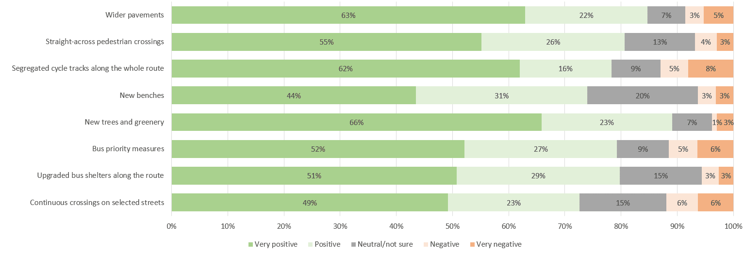
Respondents were asked to feedback on proposal elements along the whole of the route. Results showed that the eight proposals received 72% of support or above:
- Wider pavements (85% in support)
- Straight-across pedestrian crossings (81% in support)
- Segregated cycle tracks along the whole route (78% in support)
- New benches (75% in support)
- New trees and greenery (89% in support)
- Bus priority measures (79% in support)
- Upgraded bus shelters (80% in support)
- Continuous crossings (72% in support)
Results for individual sections
Design changes as a result of the consultation
We have made the following changes to the proposals based on consultation feedback from the public, as well as external and internal stakeholders. Where there are no changes to the proposals, we will be proceeding with them as originally consulted on.
Section 1: Albion Street and Woodhouse Lane from Wormald Row to Clay Pit Lane
| Initial proposal | Location | Change | Reason |
| Remove the existing staggered signalised pedestrian crossing over Woodhouse Lane at Vernon Street. The pedestrian crossing outside Merrion Centre entrance would serve pedestrians. | Woodhouse Lane at the junction of Vernon Street. | A signalised pedestrian crossing over Woodhouse Lane at Vernon Street will be retained and become a straight-across pedestrian crossing. The signalised pedestrian crossing at the Merrion Centre entrance will also be retained. | Consultation feedback indicated that the existing signalised pedestrian crossing in this location is well-used because it caters to a strong pedestrian desire line. |
| Remove existing vehicle/taxi drop-off outside Morrisons on Woodhouse Lane and replace with alternative pick-up/drop-off locations nearby. | Woodhouse Lane, near Morrisons. | The pick-up and drop-off point outside Morrisons will be retained, but bollards will be installed around it to prevent vehicles mounting onto the pavement and the Merrion Centre loading area exit. | Feedback indicated that this pick-up and drop-off point is valued by Morrisons customers, especially for disabled and the elderly who may struggle to leave the store, with shopping bags. Other feedback noted that vehicles using the current pick-up and drop-off facility tend to invade the pavement and Merrion Centre loading exit. |
| Wider pavements on both sides of Woodhouse Lane, between Merrion Street and Clay Pit Lane. A continuous southbound bus lane, to be provided from Clay Pit Lane to outside The Merchant Pub. | Woodhouse Lane, between Clay Pit Lane and Great George Street. | Additional pavement widening will be delivered between Vernon Street and the Merrion Centre entrance not delivering the proposed bus lane between the Morrisons car park entrance and Rossington Street. | Feedback indicated that the original proposals did not go far enough to provide improvements for pedestrians in this area. Officers are confident that the reduction of the bus lane proposal in this area will not negatively impact day-to-day bus reliability. |
| Initial consultation drawing showed a continuous crossing, that vehicles could enter/exit, at the Vernon Street junction with Woodhouse Lane. | Vernon Street, at the side of The Hedley Verity. | Since consultation the junction of Vernon Street and Woodhouse Lane has been closed to motor vehicles. This has also allowed The Hedley Verity to have outside seating. | Motor vehicle access to Vernon Street has changed since the consultation. |
| Initial consultation map showed raised table just at the junction of Wormald Row. | Junction of Albion Street and Wormald Row. | The proposed raised table only at Wormald Row junction will now be extended to include the pedestrian crossing on Albion Street, outside Turtle Bay. | Feedback indicated that a wider raised table here would improve pedestrian safety and control vehicle speeds. |
| Tighten Wormald Row junction creating wider pavements and a shorter pedestrian crossing distance. This is facilitated by relocating two existing blue badge parking spaces to Rossington Street. Four blue badge spaces retained on Wormald Row. | Wormald Row. | An additional blue badge space on Wormald Row will be relocated to deliver additional footway widening. Four blue badge bays will in total be relocated from Wormald Row to Perceival Street and Wade Lane. | Feedback indicated that the proposals did not go far enough to provide pedestrian and road safety improvements on Wormald Row. |
Section 2: Woodhouse Lane from Clay Pit Lane to Blackman Lane
| Initial proposal | Location | Change | Reason |
| New straight-across pedestrian crossing at Woodhouse Lane Car Park. | Woodhouse Lane Car Park and green area around The Dry Dock. | A footpath will be constructed in the greenspace around the Dry Dock, linking the new pedestrian crossing to existing footpaths in the greenspace. | Feedback indicated that there is an existing desire line through this greenspace, which is not currently catered for. The new pedestrian crossing near Woodhouse Lane car park will line up with this desire line. |
| Consultation suggested no changes to existing pedestrian crossings on Portland Way. | Portland Way. | Pedestrian crossings over Portland Way will be widened and shortened. | Feedback indicated that the original proposals did not provide enough improvement for pedestrians at this junction which is very well-used. The changes will make the crossings more convenient for pedestrians. |
| Initial consultation drawing kept existing white line separation for northbound and southbound lanes on Woodhouse Lane, between Portland Way and Clay Pit Lane. | Woodhouse Lane, between Portland Way and Clay Pit Lane. | A kerbed separator median will be added on Woodhouse Lane, between Clay Pit Lane and the Portland Way junction, separating the northbound and southbound lanes. Gaps will be provided to allow cycles to access Queen Square and Queen Square Court. | Feedback indicated that there is a risk of vehicles making prohibited turns and U-turns here, which creates a safety risk for pedestrians and cycle users at side roads. The median will physically block these dangerous manoeuvres. |
| Initial consultation drawing showed one-way cycle tracks on the north and south sides of Clay Pit Lane and staggered pedestrian crossings on Clay Pit Lane. | Clay Pit Lane, junction with Woodhouse Lane. | A two-way cycle track will be provided adjacent to Merrion House, providing direct access to Leeds City Council Merrion House. The two pedestrian crossings over Clay Pit Lane will become straight-across crossings. | Feedback indicated that the cycle lane would benefit from not being on either side of the road and be two-way instead. |
| Initial consultation drawing left existing footway on Cookridge Street untouched. | Cookridge Street. | There will be localised footway widening on the west side of Cookridge Street outside O2 Academy. | Feedback indicated that the existing footways are too narrow to cater for demand, especially during events at O2 Academy. |
| Initial consultation drawing showed removal of motorcycle parking on Cookridge Street. | Cookridge Street. | Motorcycle parking will be retained on Cookridge Street in a location close to the current site. | Feedback indicated that secure motorcycle parking is generally valued throughout the city centre. |
| Two-way, segregated cycle track on Woodhouse Lane. | Cycle track on bridge over Inner Ring Road between Leeds Beckett University and Broadcasting Place. | The cycle track here will be built using light segregation (wand and orcas) rather than traditional kerbs as these are not feasible on the bridge. | Officer feedback has indicated that it is not feasible to deliver traditional kerbs on the bridge. |
Section 3: Blenheim Terrace and Blenheim Walk from Blackman Lane to St Mark’s Road
| Initial proposal | Location | Change | Reason |
| Initial proposal showed no paid short-stay parking on St Mark’s Road. | St Mark’s Road. | A new area of short-stay paid parking will be created on the east side of St Mark’s Road, just north of its junction with Blenheim Walk, with the first hour being free. | Feedback indicated that short-stay parking in this area is valued, so this new parking will mitigate some of the parking removed on Woodhouse Lane. |
| Consultation drawings showing pedestrian crossings at junction of St. Mark's Road with Woodhouse Lane. | Junction of St Mark’s Road and Woodhouse Lane. | Changes to where the pedestrian crossings are placed. | Feedback indicated that the original crossing proposals did not align with pedestrian desire lines. |
| Initial consultation drawing showed one loading bay in this area. | Blenheim Terrace, east side, just south of St Mark’s Road near Bakery 164. | The proposed on-footway loading bay on Blenheim Terrace, between Blackman Lane and Back Blenheim Walk, will be lengthened and made an on-carriageway bay. A second on-carriageway loading bay will be created just south of Back Blenheim Terrace. | Feedback indicated that more space was required for loading and pick-up and drop-off in this area. Stakeholders also advised that on-footway loading bays are not accessible for all users and can lead to vehicle encroachment onto the footway. |
| New, wider, straight-across pedestrian crossings located at Blenheim Terrace outside the Laidlaw Library. | Blenheim Terrace outside The Laidlaw Library. | The pedestrian crossing on Blenheim Terrace, outside Laidlaw Library will be relocated further up above the Cavendish Road junction. | Feedback indicated that the original proposal did not best meet pedestrian desire lines from the University of Leeds campus. |
| Relocate taxi rank on Cavendish Road to a location nearby. | Cavendish Road. | A taxi rank will be provided on Cavendish Road, close to the location of the existing rank. A length for general pick-up and drop-off will also be provided. A turning area will be provided on Cavendish Road to allow vehicles to turn without entering the University of Leeds campus. | Feedback indicated that the existing rank is valued. Feedback from stakeholders and the public also indicated that space for general pick-up and drop-off is required. Stakeholders also advised that vehicles should be able to turn in Cavendish Road without having to enter the University of Leeds campus. |
| Create a new taxi rank on Cromer Terrace. | Cromer Terrace. | A new taxi rank on Cromer Terrace will not be provided. | Feedback indicated that this was not a suitable location for a new taxi rank. As noted above, taxi rank provision will be retained on Cavendish Road. |
| Initial consultation drawing showed removal of off-peak parking on Blackman Lane. | Blackman Lane, west of Blenheim Walk. | Space for off-peak parking will be retained on the south side of Blackman Lane, near Blenheim Baptist Church, by reducing the amount of footway widening. | Feedback indicated that the existing off-peak parking is valued by users of Blenheim Baptist Church. |
| Consultation drawing showing cycle track at Blackman Lane East junction with Woodhouse Lane. | Blackman Lane East junction with Woodhouse Lane. | The alignment of the cycle track crossing here has changed slightly. | Feedback indicated that the cycle track and footway at this junction was too constrained. The revised proposal offers more spacious provision. |
| Initially, not in scope of consultation. | Blackman Lane East and Lofthouse Place. | The footway will be built out around the junction of Lofthouse Place and Blackman Lane East. A zebra crossing will be provided on the eastern arm of the junction and uncontrolled crossings will be provided on the other arms. Some changes to short-stay parking will be made. | Feedback indicated that stakeholders have road safety concerns with the current layout, especially at school pick-up and drop-off times. |
| Initially, not in scope of consultation. | Blackman Lane East and Leicester Place. | New areas of controlled parking will be created. | Feedback indicated that this uncontrolled parking is utilised by commuters, so it is rarely available for access to the local area. |
Section 4: Woodhouse Lane from St Mark’s Road to Spenceley Street
| Initial proposal | Location | Change | Reason |
| Consultation plans showed two bus stop boarders on this section of Woodhouse Lane. | Woodhouse Lane, between St Mark’s Road and St Mark’s Street. | Designs for bus stop treatments in this area will be amended so that the designs are compliant with emerging government guidance. | Officers need to ensure the designs are compliant with emerging government guidance. |
General
The proposals for tree planting, presented in the consultation plans, will be rationalised in line with what is deliverable.
Next steps
Officers will now undertake a procurement exercise to secure a contractor and finalise the construction programme. You can view a timeline of the scheme here.
Discover more
Survey
View detailed plans for the second round of consultation and feed back on them.
First consultation - Results
View the analysed feedback of the first round of consultation.
Events
Attend an in-person drop-in event to have your say in the consultation.
Frequently asked questions
View frequently asked questions about the scheme.
Step 3: Priorities
Help us prioritise improvements around the Woodhouse Lane Gateway.
Step 2: Changes
Let us know what changes you would like to see to enhance transport and place along the Woodhouse Lane Gateway.
Step 1: Current issues
Tell us about issues related to transport or place along the Woodhouse Lane Gateway.
Stay Informed
Follow our projects to get notified of upcoming engagements and the latest project related news.