
Thorner Beck Flood Alleviation Scheme
Find out how we’re reducing the risk of flooding to properties in Thorner from Thorner Beck
Leeds City Council Flood Resilience
Thorner Beck Flood Alleviation Scheme
Find out how we’re reducing the risk of flooding to properties from Thorner Beck with our flood risk study.
Why Thorner Beck needs flood protection
Thorner village has a history of flooding from Thorner Beck, with the most notable event in June 2007. The Environment Agency post-flood report indicated a total of 17 properties that were flooded internally. The flooding occurred along Carr Lane, Mexborough Court, Sedgegarth, Kirkby Garth and Lower Sandhills Road.
Leeds City Council has secured funding to investigate flood risk from Thorner Beck and develop option to reduce the risk.
What we’re doing to reduce the risk of flooding
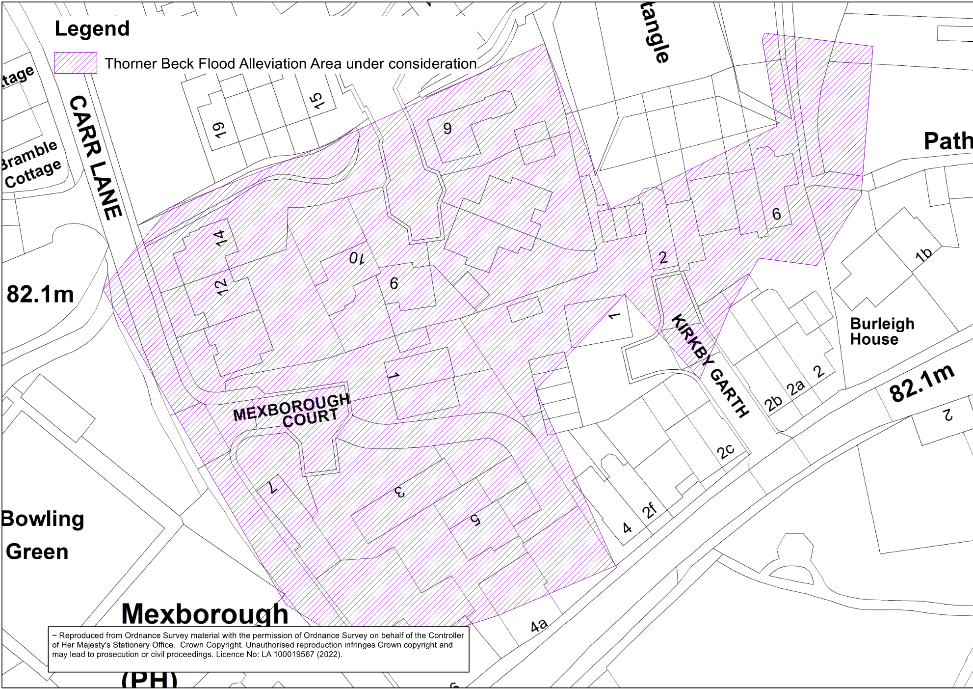
[The area of Thorner that this study is aiming to protect]
A study of Thorner Beck has been completed by the Environment Agency to update flood mapping in the area. This model was used by Leeds City Council for a feasibility study into schemes to alleviate flood risk from Thorner Beck.
Work on the feasibility study started in 2022. This phase of work included the following activities.
- River Modelling
- Surveys of Thorner Beck
- Options appraisals
The feasibility study assessed a range of options using several criteria, such as hydraulic effectiveness, environmental impact, cost and economic viability. This stage has been completed now and a preferred option has been identified.
Preferred Option
Our preferred option is a combination of three parts:
Preferred option parts 1 and 2 – Westfield Lane storage area/embankment and infill of low spot
Our aim is to mimic a natural process by creating a flood embankment with a flow control to slow the flow and store more water in a field that already floods when river levels are high. The proposal is:
- Construction of a 60m long earth embankment with a clay core across the field by Westfield Lane. The height will be an average of 1m tying into the existing field/high ground to the South West and tying into the wall on the North East.
- Installation of a new headwall with a flow control to store water in the field more frequently and control the amount of water that flows through in high rainfall events.
- Infilling of the low spot that has been identified by local residents and our modelling at Lower Sandhills, bringing the height of the channel in line with the rest of the existing riverbank.
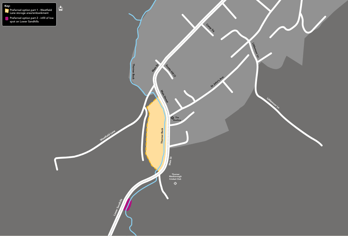
A map of the preferred option parts 1 and 2
Preferred option part 3 – natural flood management (NFM)
We have been working with Yorkshire Dales Rivers Trust (YDRT) to scope opportunities for NFM throughout the Thorner Catchment to slow the flow of water into Thorner Beck. This has the added benefit of also improving water quality in the beck.
The wider catchment NFM opportunities aim to increase the long term resilience of the scheme by using natural interventions through the catchment. YDRT have identified several opportunities throughout the catchment such as:
- Soil Aeration
- Hedge planting
- Leaky barriers
- Scrape/Ponds
- Tree planting
- De-culverting opportunities
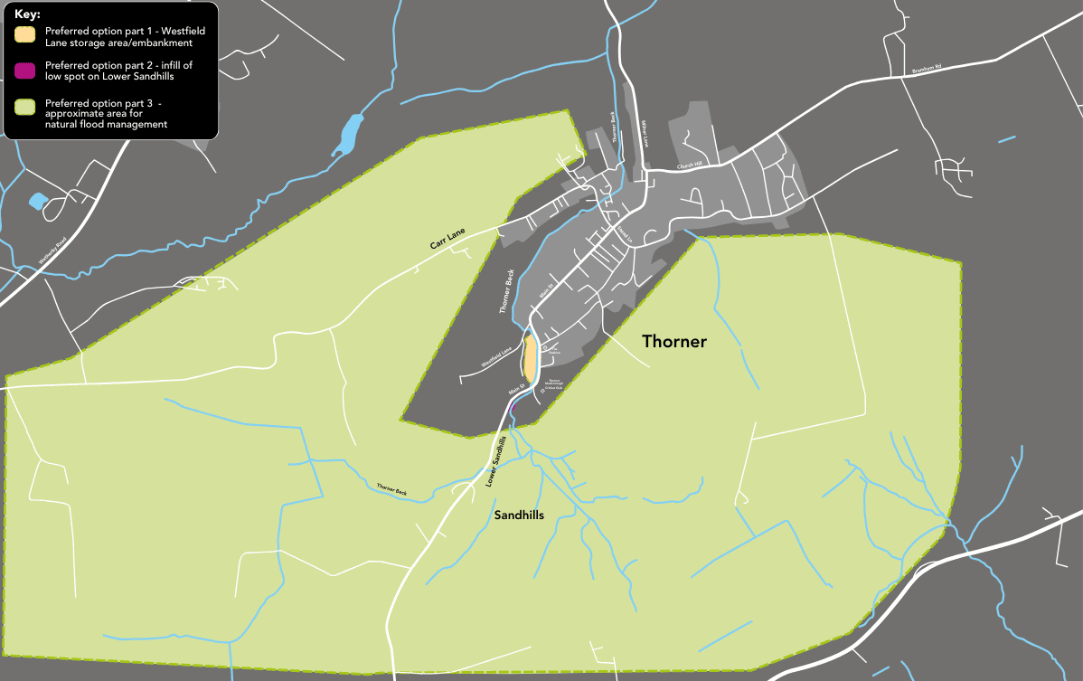
A map of the preferred option part 3
If these options were to be implemented, they would result in effectively more than halving the likelihood of flooding from Thorner Beck.
In technical terms, it would reduce the predicted onset of flooding from occurring in a 1-in-20-year event (5% AEP) to a 1-in-50-year event (2% AEP).
Engagement in September 2025
In September 2025 we engaged with the public on the preferred option both online and in-person at the Victory Hall in Thorner.
Below are responses to the feedback that we received during that process:
Next steps
We are working to the following timelines to deliver the scheme:
- The Natural Flood Management Implementation began in June 2026 and will continue through to the end of 2027
- We will be submitting our planning submission at the end of 2026, with a view to start construction works in the summer of 2027
Surface Water Flood Risk
In 2024 Thorner was impacted by three significant surface water flooding events in May, July and December. These events resulted in flooding on Main Street, Carr Lane, Stead Lane & Mexborough Court. The flooding from surface water is being investigated separately to this scheme, with information to be provided in the due course.
Contact us
Follow this link to sign up to our mailing list.
For any more information, please email us at FRM@leeds.gov.uk and include ‘Thorner Beck flood risk study'.
Discover more

Hybrid Ecologies: Creative Interpretation at Sheepscar Beck
There's a new engaging artwork coming to Sheepscar Beck, co-created by the local community and artist Katie Surridge, inspired by the hidden wildlife in our urban environment.
Farnley Wood Beck Natural Flood Management scheme
Find out how we're delivering NFM measures to help reduce flood risk
Leeds Flood Alleviation Scheme Legacy Information
Sheepscar Beck Flood Alleviation Scheme Legacy Information
Find out more about the scheme to repair and sustain the existing level of flood risk in the area.
Leeds Flood Alleviation Scheme Murals
Information on the installation of two murals on the Leeds FAS control room buildings

Consultation - Flood Risk Management Strategy
Have your say on our draft Local Flood Risk Management Strategy
Feedback on the Meanwood Valley Farm Demonstrator Site and Meanwood Rain Chain
A short survey to accompany the information given at the Meanwood Valley Farm Summer Fair
Thorner Beck Flood Alleviation Scheme Preferred Option
Have your say on the preferred option for reducing flood risk to properties in Thorner from Thorner Beck

Sheepscar Beck FAS
We aim to carry out repair works to sustain the existing level of flood risk in the area.
Stay Informed
Follow our projects to get notified of upcoming engagements and the latest project related news.