Frequently Asked Questions
Lloyd Park & Higham Hill Area Improvement Scheme FAQs
What is an Area Improvement Scheme?
An Area Improvement Scheme aims to take a holistic approach to tackling key highways and transport issues with an area, rather than looking at single roads or streets in isolation. Where possible, we also try to look beyond just tackling problems around traffic and safety, and aim to include a range of different measures that will deliver different benefits. Examples include improving the appearance of the area, creating more informal play space, or incorporating measures that will help reduce the impact on flooding. Taking this area wide approach and including different types of improvements generally results in the greatest overall benefits
What are the aims of the scheme?
One of the main reasons for developing schemes such as this is to make our roads safer places to travel along for the many people who use them, such as children walking, scooting or cycling to school, and people who walk and cycle locally. We also want to improve air quality, enhance the look and feel of the area, and encourage more people to feel safer and confident using more sustainable modes of transport.
At their heart, schemes like this aim to reduce the number of motorised vehicles (such as cars, vans, motorbikes etc) that use our residential areas. By reducing traffic volumes and speeds, we also see a reduction in noise and air pollution, making residential streets more enjoyable places for people to travel along and spend time. We also want to improve the look and feel of the area, support local businesses, and tackle other issues associated with climate change.
The core aims of the scheme are to:
- Reduce the amount of non-local traffic using residential streets
- Improve the look, feel and safety of the streets for all
- Improve routes to and from local schools, shops, local amenities, and places of interest
- Encourage people to use sustainable, active, and healthy modes of transport.
How is the scheme being funded?
In 2019, we submitted a Liveable Neighbourhoods funding bid to Transport for London (TfL) but unfortunately it was unsuccessful.
The current scheme is currently being funded by the Council and TfL
Why is this scheme needed?
The Council is committed to creating streets and neighbourhoods that are safe, attractive and actively encourage walking, cycling and the use of public transport. Walking and cycling in particular can have significant benefits for our personal health and the environment, and are a means to help tackle key priorities for the Council including the public health, air quality and climate crises within the borough. Creating streets and spaces that support and enable active and sustainable travel, particularly for local journeys, is a fundamental part of the Council’s 15-minute Neighbourhoods approach and Climate Action Plan
Over the last few years we have seen more and more people walking and cycling in the borough, and since the Covid-19 pandemic we have seen this increase even further
Through the delivery of the scheme, we will ensure our roads are safe for the many people who have benefitted from walking and cycling more over the last few months and years, and will encourage and enable more people to do the same. The scheme will also help people stay physically active and healthy, improve air quality, reduce road danger and encourage a further shift to more sustainable modes of transport.
With less traffic, noise and pollution, our streets will be safer and more pleasant to use, especially for children to cross the road and walk and cycle to school. It will also reduce the level of harmful emissions from motorised vehicles driving through the area, which can cause serious health problems. Public Realm improvements help enhance the look and feel of the area, creating a greater sense of community pride and ownership. They can also help tackle concerns around anti social behaviour, fly tipping and personal security. Incorporating more trees and planting, as well as sustainable urban drainage can have many benefits in terms of improving air quality, increasing biodiversity and providing mitigation against climate change and significant extreme weather events which are becoming more regular.
What does the scheme involve?
One of the main components of the scheme is the implementation of modal filters (roads closed to motorised vehicles) in two areas, which are called Series 1 and Series 2.
Series 1 is bounded by Billet Road, Chingford Road, Forest Road, and is also bounded by and includes North Countess Road, Priory Court and South Countess Road. A total of seven modal filters are proposed in this area.
Series 2 is bounded by Forest Road, Higham Hill Road and is also bounded by and includes Queen Elizabeth Road, Blenheim Road and Blackhorse Lane. Two modal filters are proposed in this area.
It is hoped that majority of modal filters, subject to discussions with the emergency services, will be created with phsyical measures at various locations to restrict access for motorised vehicles but will still allow pedestrians and cyclists to travel through. These could include some small scale planting areas or spaces for community use. However, we expect that some modal filters will be enforced via CCTV and there will not be a physical barrier in place. This is to allow access for emergency vehicles and other authorised vehicles only. All other motorised vehicles will not be allowed to travel through these modal filters and will be issued with a Penalty Charge Notice (PCN) if they do.
All addresses will be accessible via motorised vehicle including emergency services, but drivers may need to use a slightly different route. Locations of the modal filters are shown on the plan overleaf and more information can also be accessed via https://lloydhigham.commonplace.is/
Will there be an increase in traffic on main roads?
We understand that there is sometimes concern that installing modal filters in some streets will increase traffic volume, congestion and pollution on other roads in the surrounding or wider area, particularly the main road network. While the main road network has traditionally been designed to accommodate higher volumes of traffic – wider roads and pavements, buildings set back further from the road, etc, we recognise that this is not always the case. While the main road network also typically contains higher concentrations of retail, commercial and industrial land use we also understand it can, and does, include some residential properties, and more generally is used by a large number of people walking and going about their daily activities each day.
As well as looking at the health and well-being of our residents, we know we need to ensure that our main roads can continue to manage the level of traffic that uses it as well as keeping users as safe as possible.
Modal filters have been installed across the borough for many years, and data collected as part of more recent schemes shows that the impact on the wider road network, particularly the main roads, varies on a scheme by scheme basis. In some schemes there has been an initial impact on the main road network, and in others there has not, based on the data we have collected. In most schemes we see an overall reduction in traffic volumes across an area (taking all roads into consideration, including the main road network), but the overall reduction level depends upon the scheme in question as elements such as size, location, road layout, local businesses, schools, amenities, etc, all have an impact on how people may travel to or around these areas.
Our overall plan is to make all roads across the borough safer and healthier places and we have to start somewhere if we are going to achieve a meaningful shift towards more sustainable modes of transport such as walking, cycling, and public transport for local journeys across the borough, as well as journeys further afield. We’re doing this by introducing traffic reduction schemes in some of our neighbourhoods, introducing a 20mph speed limit on our main roads, creating more and better pedestrian crossings, making our pavements better and wider, adding more seating and greenery, and looking at traffic light improvements. Most importantly we’ve created miles of cycling routes, including semi and fully segregated cycle tracks, throughout the borough making journeys between town centres and into other boroughs direct and safe.
If more people were to make a shift towards sustainable transport, our roads would benefit from a huge reduction in air and noise pollution, and our roads would become safer overall. However, we know that people still need to make journeys by motorised vehicles for numerous reasons such as for work and due to disabilities etc, and so we’re also keen to encourage more residents to use car club schemes, car share or switch to zero emissions vehicles.
How can local people get involved and have their say?
The views of local people are important to the success of this scheme, and to help us develop the scheme as it progresses, we will need your feedback to help us understand if improvements to the scheme are needed.
Over the next six months local people will be able to leave feedback by visiting
https://lloydhigham.commonplace.is/
Here you will be able leave comments on specific locations and sign up to scheme updates.
At key milestones in the project, we will invite local people to complete a series of questions to give us more detailed feedback, which will help us develop a permanent scheme. This will be done through the CommonPlace website, so please sign up to updates if you would like to be notified.
If you do not have internet access please write to us at the contact details below and we will send you a printed copy of the map.
Enjoy Waltham Forest
Low Hall Depot
Argall Avenue London
E10 7AS
We are also holding two informal drop-in sessions where you can come and talk to us about the plans.
Join us at any of the drop-in sessions shown below:
- Wednesday 7 December (5pm-7pm) One Hoe Street 1 Hoe Street, London E17 4SD
- Saturday 10 December (12pm-2pm) Priory Court Community Centre 11 Priory Ct, London E17 5NB
Where can local people find out more information about the scheme?
Everything you need to know about the scheme and how you can get involved can be found online by visiting https://lloydhigham.commonplace.is/ Here you will be able leave comments about the scheme at specific locations as well as sign up to scheme updates.
We will be keeping local people updated through the commonplace site, so please agree to receiving updates to be kept informed. We will also continue to update all residents through our usual council communications channels such as twitter @wfcouncil, Facebook, and our resident enews.
What is a modal filter?
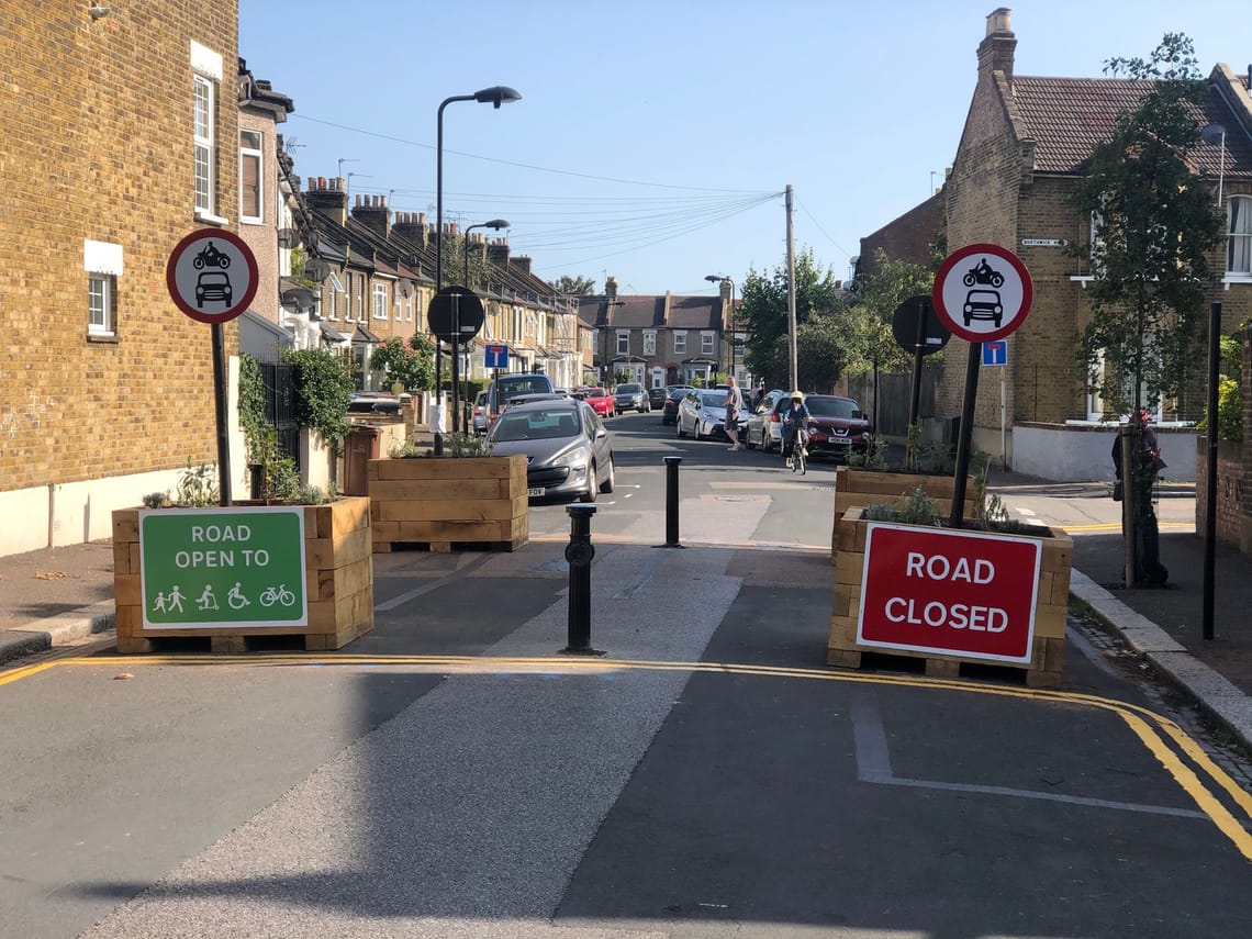
A modal filter is when a physical barrier such as a planter, gate, bollards etc is installed at a key location in a street to stop motorised vehicles from driving through, however people who walk and cycle can still travel through.
These modal filters are used to stop vehicles using the area to bypass the main roads. All properties on the road remain accessible for local residents, emergency services, deliveries etc, however the way these properties are accessed may change and journey times can sometimes increase.
Although it may take slightly longer to access properties, this will not increase air pollution as overall the area will see a huge reduction in traffic leading to improved air quality.
As with all traffic schemes it can often take a few months for changes to bed in. So we kindly ask residents to familiarise themselves with their new journeys and allow time for the scheme to take effect.
Feedback from local people is always welcome and encouraged to help us develop a scheme in partnership. You can share your thoughts by visiting our online map based survey https://lloydhigham.commonplace.is/ as well as sign up to receiving updates on the scheme.
Example of Modal Filter with planters and bollards
What data monitoring/ collection do you have in place to assess the scheme?
Traffic Volume and Speed - As part of the original Liveable Neighbourhoods scheme bid in 2018 a range of traffic related data was collected in Autumn 2018 and 2019 to help understand vehicle movements within and outside the area. A further area wide survey is taking place in Nov / Dec 2022.
These surveys will provide the following baseline information to be collected/estimated
- Traffic volumes and speeds on many roads within the area and on the boundary
- Queue lengths at the junctions of Higham Hill Road / Forest Road and Blackhorse Lane / Forest Road
Collision and Personal Injury Data
As part of the 2019 Bid to TfL an analysis of collision/personal injury data was undertaken. The analysis showed that in the 5 years between October 2013 and September 2018 there had been 116 collisions within the original Liveable Neighbourhood bid area, of which 10 resulted in Serious or Fatal injuries. The original bid did however cover a wider area than the current series 1 and 2 proposals, and so our analysis will take this into consideration so we are comparing like for like
Air Quality monitoring – We are currently investigating the installation of air quality monitors in the area
Bus Impact - Working with Transport for London, we will monitor the impact on bus services using TfLs “Ibus” system, which allows any changes to bus journey times between stops to be assessed. Where possible will also monitor passenger numbers using TfLs Bus Origin and Destination survey data
Crime and Emergency Response Time data - Working with data from the Police and Fire Brigade, as we have done in the past, we will be able to compare crime and response
How can the emergency services access my property?
Emergency service access is vital which is why they are statutory consultees, meaning we must engage with them and agree plans before progressing with a scheme.
Throughout our schemes we meet with and keep the emergency services up to date on our plans to ensure there are no issues with how they can access the area should they need to.
After initial talks with the emergency services for the these proposals we are reviewing the locations which would need to be camera enforced modal filters .
This means there is no physical barrier in the road, however all motorised vehicles other than the emergency services will receive a penalty charge notice (PCN) should they travel through.
How can I access my property?
All properties will be accessible however the way you reach your property, and your usual journeys may change. As with all changes to the highway it can take a few months for people to get used to the new layouts. Please take the time to view the map and any changes to your regular journeys.
Don’t forget to share your thoughts on the scheme by visiting https://lloydhigham.commonplace.is/
Will there be a loss of parking?
To make space for the modal filters and to allow a safe turning zone for vehicles, some parking bays will be removed on both sides of the modal filters. Please see the map of the scheme for full details on modal filter locations.
As this scheme is designed to enable more people to do local journeys by walking, cycling and using public transport, we anticipate that over time there will be a reduction in car ownership across the area which will help free up road space for the people who need it.
How will these proposals affect businesses?
It is a common misconception that customers drive to local businesses and therefore removing parking or access into nearby residential areas will have a negative impact on them.
However, we know that people who walk and cycle are great customers for local shops and high street surveys show that whilst people who cycle don’t spend as much as a car driver per trip, they visit shops more regularly and spend more per week.
By making our streets feel safer, cleaner, less congested, less polluted and by providing places for people to enjoy, people are encouraged to spend more time in their local areas and over time choose to walk and cycle more. Plus, investing in walking and cycling projects can increase retail sales by 30% (Pedestrian Pound, Living Streets 2013).
What will the impact be on disabled or less mobile residents?
We understand that people still need to drive for certain journeys, however we need people to walk, cycle and use public transport more for local journeys if they’re able to do so, which will free up space on the roads for those people who need to make trips by car.
There may be a change to how you carry out your usual journeys or travel to and from your property and we appreciate that this can be disconcerting. We therefore really want to get the views of local residents who are registered as having a Blue Badge, people who are less mobile, and people who have a disability or look after someone with a disability, to help us shape a scheme for the area. If you would like this leaflet in larger print or have any other requests to enable you to respond to the consultation, please contact us using the details above
What are the outcomes from other similar schemes in Waltham Forest?
The monitoring we have undertaken on schemes delivered over the last few years, and our programme as a whole, has shown:
- Traffic levels have generally decreased overall
- Speeds have reduced
- Collisions have either reduced, or at worst stayed the same.
- The impact on the surrounding road network varies on a scheme by scheme basis, as discussed earlier. In the short term there is often some impact but over time it settles. Some parts of the surrounding network have seen increases and some parts have seen decreases, with the overall impact largely neutral.
- Bus journey times have not been significantly affected
- Instances of Anti Social behaviour and Crime have improved in some areas, and have generally not worsened – based on an analysis of Police and Council data
- London Fire Brigade response times have improved in some areas, and as above have not worsened – based on London Fire Brigade data.
- Cycling has increased, both in scheme areas and across our network of permanent cycle counting sites. Since 2016 we have seen the number of people cycling across our count sites more than double.
In addition to our own monitoring, independent research has shown that the interventions that have already been introduced through the Enjoy Waltham Forest programme have encouraged residents to walk more, which is great for their health. Dr Rachel Aldred of Westminster University surveyed residents across London and found that those living in areas that have received “High dose” Mini-Holland interventions were walking on average 34 minutes more a week.
A summary of the outcomes from some of the key pieces of independent research can be seen below
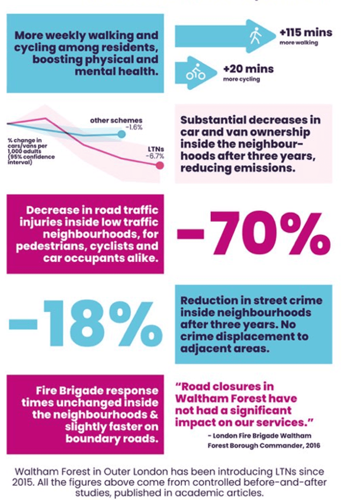
Recent research from the Department for Transport has shown that Waltham Forest is the 2nd highest Outer London Borough in terms of people cycling for travel at least once a week. Also 48% of Waltham Forest residents walk at least once a month according to DfT stats, placing us 2nd in Outer London.
Changing travel behaviour
We all know we need to do our bit to improve our health and the quality of the air we breathe. By making small changes to how we travel for short journeys we could see a huge benefit to our health, our wellbeing and our pockets.
There are many reasons why people feel they need to travel by car, such as time saving, weather, distance, safety, however driving is not always the quickest, easiest, or best option for all journeys, especially when traveling locally.
A report on the “health impact of cars in London” from the Greater London Authority (GLA) highlights 1/3 of car journeys in London are less than 3km and 2/3 are less than 5km. London residents make 7.3 million car trips as a driver or passenger in London per day on average. Of these car trips over 50% are made for shopping, leisure and personal business purposes, 19% are made for work purposes, 5% for education, 22% for other purposes including worship and escorting others such as children to school.
On average it takes up to 12 minutes to walk 1km, so if we made a change and chose to walk or cycle for journeys less than 3km we could see a huge reduction in the number of people driving daily.
Whilst there will be many residents happy to join the walking and cycling revolution there will be some people who may be reluctant or unable to make the switch. If the majority of people make the switch for some journeys we hope the roads will be freed up for the people who need to use them.
Stay Informed
Follow our projects to get notified of upcoming engagements and the latest project related news.