Peaks Island Shoreline Stabilization Project
Introduction
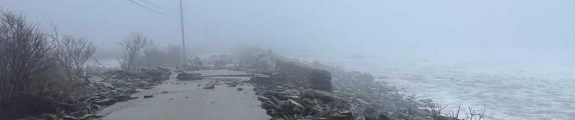
The Peaks Island Seashore project is a FEMA authorized repair project under Disaster Declaration 4764-DR-ME, established in response to severe storm surge and surface flooding between January 9 and January 13, 2024.
Project Goals and Funding
The primary objectives are to protect existing public infrastructure, stabilize the eroding shoreline, and repair damaged roadways. The project is supported by $6,009,458 in FEMA/MEMA/City funding. The funding match is a 75/15/10 split, where FEMA contributes 75%, MEMA contributes 15%, and the City contributes 10%. This includes $5,235,295 dedicated to repairing infrastructure back to its pre-storm state and $774,163 allocated for mitigation measures future storm events.
Scope of Work
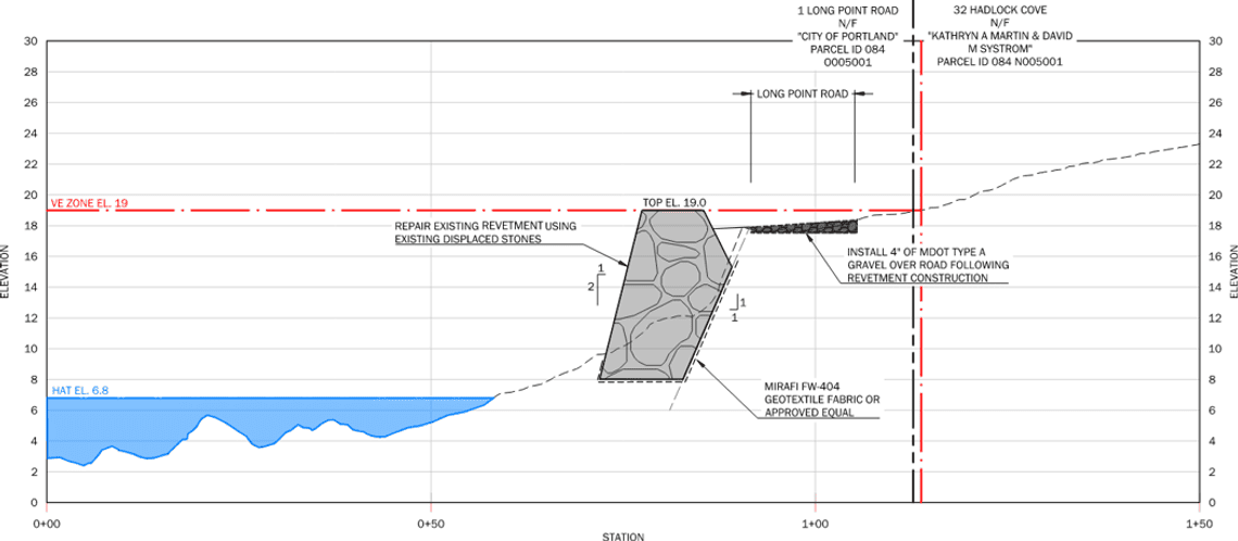
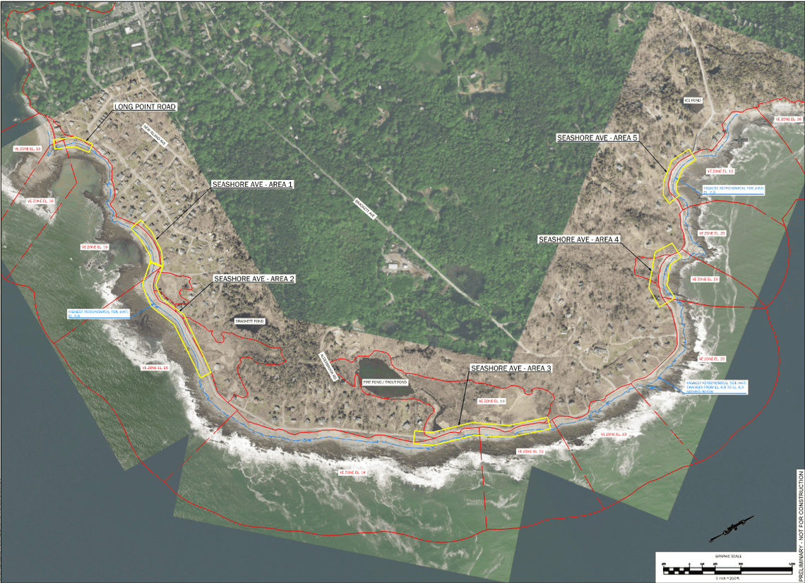
Long Point Road: This area will be restored to its pre-storm condition. The work includes repairing the existing riprap revetment, replanting lost native vegetation, and fixing the gravel roadway surface.
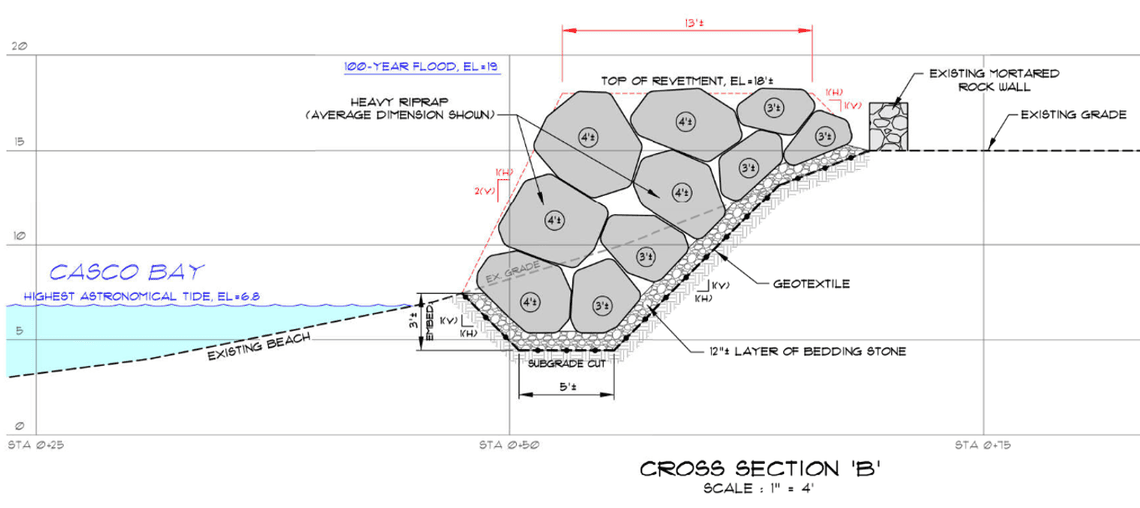
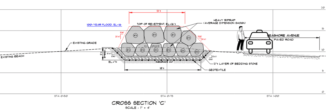
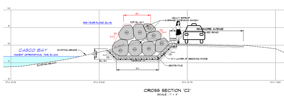
Seashore Avenue: The project targets five specific locations along this road for both repair and mitigation as identified by FEMA. Improvements include installing adequately sized riprap revetments built relative to base flood elevations. The project will also repair the damaged roadway and resolve existing drainage issues in these areas.
Basis of Design
- Limited to the areas and repair methods identified by FEMA
- Revetment was chosen instead of living shorelines because this is a high wave energy environment
a. Riprap sizing calculations show that 4+ foot diameter rock is required to withstand wave energy and buoyancy
i. 4 to 5 foot diameter rock = 8,000 to 16,000 pounds - Height of revetment
a. Designed revetment top elevation to meet base flood elevation (100-year storm) where feasible - Spatial constraints for design:
a. Limited to the area owned by the City of Portland/within the City’s ROW
b. Limited to the area between the high tide line and the roadway - Budget constraints
a. Design a project that is likely to meet the FEMA allocated budget (not exceed)
Peaks Island Shoreline Stabilization Project Questions & Answers
Updated 11/13/26
Design, Engineering, and Alternatives
1. What is the scientific and engineering basis for the 6-foot revetment height (specifically in Area 2), and what are the functional implications of reducing it to 3 or 4 feet?
- The original design included revetment heights of up to approximately six feet above roadway grade in some locations to approach the FEMA Base Flood Elevation (BFE), commonly associated with the 100-year storm event. The design was developed using established coastal engineering methods and guidance from agencies including FEMA, NOAA, and the U.S. Army Corps of Engineers, as well as site-specific analyses of wave action, storm surge, coastal flooding, and roadway vulnerability. The higher revetment elevations were intended to maximize long-term protection of the roadway and other public infrastructure during severe storm events.
Based on public feedback regarding views and neighborhood character, the City is revising the design to limit revetment heights to approximately 3 to 3.5 feet above roadway grade. While the lower-profile revetments will continue to provide shoreline protection, they will be more susceptible to overtopping during severe storm events than the higher revetments originally proposed.
2. Were alternative mitigation strategies fully evaluated, such as deployable barriers, stepped benches, raising the roadbed, a breakwater, or structural concrete paving anchored by drilled piers?
- Yes. The City evaluated a range of alternatives as part of the design process, including living shoreline approaches, offshore breakwaters, vertical wall systems, and riprap revetments. Other concepts, such as major roadway realignment or raising roadway elevations, were also considered conceptually, but were deemed infeasible due to cost, permitting complexity, and project delivery.
Because this project is funded through FEMA disaster recovery and mitigation programs, the selected solution must focus on protecting and repairing existing damaged public infrastructure within the approved project area and available funding. Based on engineering analyses, site constraints, constructability, long-term performance, and project eligibility requirements, riprap revetments were determined to be the most effective and practical solution for the project locations.
3. Why does the plan for Long Point Road propose replacing a previously failed revetment with the exact same undersized stones instead of using larger rocks or a breakwater?
- The FEMA-approved Damage, Description and Dimensions (DDD) framework dictates restoring the facility to its pre-disaster condition at a minimum. For Long Point Road, the design is being revised to include larger stone sized using coastal engineering calculations that account for wave forces, storm conditions, and buoyancy. Offshore breakwaters were evaluated but were not selected due to site constraints, environmental considerations, constructability challenges, and regulatory requirements.
4. Are the revetments primarily designed to protect the road from wave action, and what is the probability that replacement walls built to pre-storm specifications would be destroyed in the future?
- Yes. The primary purpose of the revetments is to protect public infrastructure, including roads, from wave action, erosion, storm surge, and coastal flooding. The proposed revetment designs use large armor stone sized to withstand site-specific wave forces and storm conditions, weighing approximately 8,000 to 16,000 pounds. While no coastal protection measure can eliminate all risk, the proposed revetments are intended to provide substantially greater protection than many of the existing shoreline features damaged during the January 2024 storm events. Replacing the masonry walls that existed pre-storm, will not protect against large storm events, as seen in 2024, and would fail again under similar storm events.
5. Can the City provide a basic cost/benefit analysis of a range of repair options (e.g., stabilizing actively eroding areas only, a 2-foot revetment, a 4-foot revetment, and the full 6-foot build-out)?
- The City evaluated multiple shoreline stabilization alternatives during the design process and prepared cost estimates for the preferred approach. The final design must balance available funding, protection of public infrastructure, constructability, regulatory requirements, and community priorities.
Based on public feedback, the City is revising the design to limit revetment heights to approximately 3 to 3.5 feet above roadway grade. This revision reduces visual impacts while also reducing the level of protection and resiliency that would have been achieved by the taller revetments originally evaluated.
6. Will the entire length of Seashore Avenue be repaved, or only the specific sections identified in the five target areas?
- Only the sections of Seashore Avenue and Long Point Road that were identified as damaged during the January 2024 storm events and included within the FEMA-funded project scope will be repaired as part of this project. Seashore Avenue repairs will be limited to the designated project areas. Long Point Road improvements will include roadway restoration consistent with existing roadway conditions. Any future roadway paving projects outside the project limits would require separate funding and authorization.
7. Has the City considered options for reconfiguring Seashore Avenue and island circulation patterns, including the eventual abandonment of sections of the roadbed?
- The purpose of the current project is to repair and protect existing public infrastructure damaged during the January 2024 storm events. As a result, the project focuses on stabilizing and protecting the existing roadway network rather than evaluating broader transportation or land-use changes. Long-term discussions regarding roadway configuration, circulation patterns, or future adaptation strategies could be considered separately from this FEMA-funded repair and mitigation project.
8. Does the design anticipate encountering ledge, and will trench excavation require blasting or hammering?
- Yes. Subsurface investigations performed during design identified areas where ledge is expected to be encountered. These conditions were incorporated into the engineering design process. Depending on actual field conditions encountered during construction, portions of the revetment may require ledge hammering or anchoring of base stones into bedrock to achieve the required stability. Blasting is not anticipated as part of the project.
9. How does the project adapt to climate change and sea-level rise without accelerating beach scouring or coastal squeeze?
- The project incorporates FEMA-funded mitigation measures intended to improve the ability of public infrastructure to withstand future coastal storm events, flooding, wave action, and anticipated sea-level rise. The selected riprap revetments protect the roadway by dissipating wave energy randomly rather than reflecting it, which is one reason they were selected instead of more rigid vertical wall systems. In addition, the revetments are adaptable and can be modified, raised, or expanded in the future if changing coastal conditions warrant additional protection.
Environmental and Hydrological Impacts
10. Have comprehensive environmental and hydrological studies been conducted to evaluate the impacts on marine life, wetlands, living systems, and adjacent shorelines?
- The project design included evaluation of existing shoreline conditions, including wetlands, coastal resources, drainage patterns, and site-specific physical conditions. The project area is characterized by rocky cobble beaches, exposed ledge, existing riprap, roadways, and other developed infrastructure.
The proposed revetments are designed to be compatible with these existing shoreline conditions and will consist of natural stone materials similar to those already present along the shoreline. Unlike a vertical seawall, a stone revetment is a permeable shoreline stabilization measure that allows water, sediment, and cobbles to move through the structure during storm events as presently occurs. The project is focused on protecting existing public infrastructure while maintaining compatibility with the existing coastal environment.
11. How will the proposed revetments and modified culverts affect inland drainage, tidal circulation, and overflow needs for the adjacent freshwater and salt marshes (specifically near Great Pond Road, Battery Steele, and the Ice, Trout, and Brackett Ponds watershed)?
- The riprap revetments are permeable structures, meaning the spaces between the stones allow water to move through the revetment during tidal cycles and storm events. As a result, the revetments are not expected to impede tidal exchange or trap water behind the structures. The project also includes targeted drainage improvements intended to improve the ability of floodwaters to drain from the roadway corridor following storm events. The design does not alter the overall watershed boundaries or fundamentally change tidal circulation patterns within adjacent pond or marsh systems.
12. Will the hard armoring cause destructive interactions, flooding, or erosion on neighboring private properties and adjacent unarmored beaches at the termination points of the structures?
- The proposed shoreline protection measures have been designed to transition into existing shoreline conditions and minimize concentrated erosion at the ends of the revetments. Unlike a vertical seawall, a riprap revetment dissipates wave energy randomly through the stone structure rather than reflecting it directly back toward adjacent shorelines. The improvements are located within City property and rights-of-way and have been designed to protect public infrastructure while remaining compatible with surrounding shoreline conditions.
13. If water overflows the revetment during a storm exceeding its design capacity, will there be adequate drainage to let the trapped water out?
- Yes. Riprap revetments are permeable structures and do not function as watertight barriers. Water can move through the void spaces between the stones and return seaward as storm conditions recede. In addition, the project includes drainage improvements in selected locations intended to improve the ability of storm and floodwaters to drain from the roadway corridor following major storm events.
14. What are the environmental implications of the construction process itself, including the potential for heavy equipment to cause erosion or destroy the existing plant barrier?
- Construction activities will be confined to the designated project area and will be performed using standard erosion and sediment control practices intended to minimize temporary impacts during construction. Where feasible, existing vegetation will be preserved and protected. In locations where vegetation must be removed to construct the revetments or complete roadway repairs, replacement plantings will be provided. Replacement vegetation will be installed based on the area of vegetation impacted, helping to maintain the existing vegetative character of the shoreline corridor following construction.
Public Access, Viewshed, and Aesthetics
15. Exactly which areas of the back shore will have views blocked by a 5- to 6-foot wall, and is this height negotiable?
- The original design included approximately 250 linear feet of revetment within Seashore Avenue Area 2 (generally in the area of the intersection of Seashore Avenue and Great Pond Road) that would have extended approximately 5 to 6 feet above the adjacent roadway grade in order to approach the FEMA Base Flood Elevation. Based on public feedback regarding views and neighborhood character, the City is revising the design to limit revetment heights to approximately 3 to 3.5 feet above roadway grade throughout the project corridor. These revisions are intended to preserve ocean views while continuing to provide shoreline protection for public infrastructure.
16. Can the City provide a digital visual simulation, photos of similar projects, or physically mark the locations with poles to accurately illustrate the viewshed impacts for pedestrians, cyclists, and vehicles?
- The City is currently revising the design to reflect the reduced revetment heights and additional shoreline access features. Updated design plans will be presented at an upcoming Peaks Island Council meeting and posted to the project webpage. These plans will provide visual representation of the proposed improvements and their relationship to the roadway, shoreline, and adjacent properties.
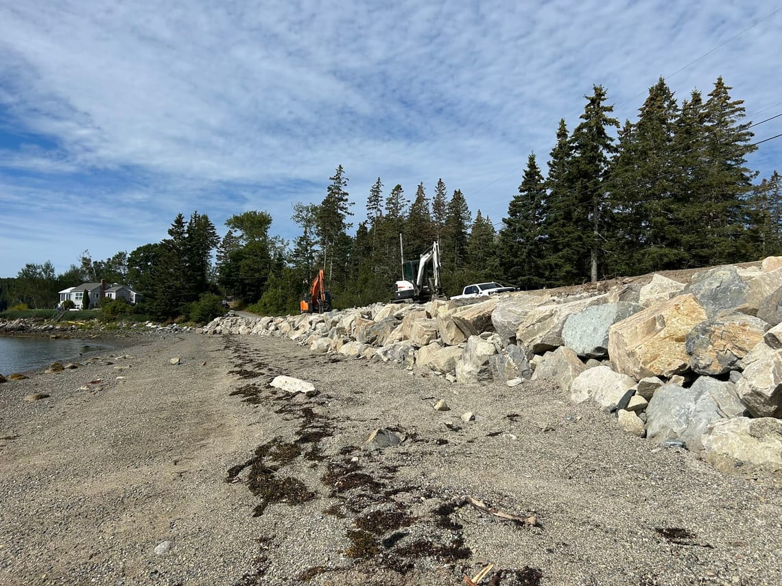
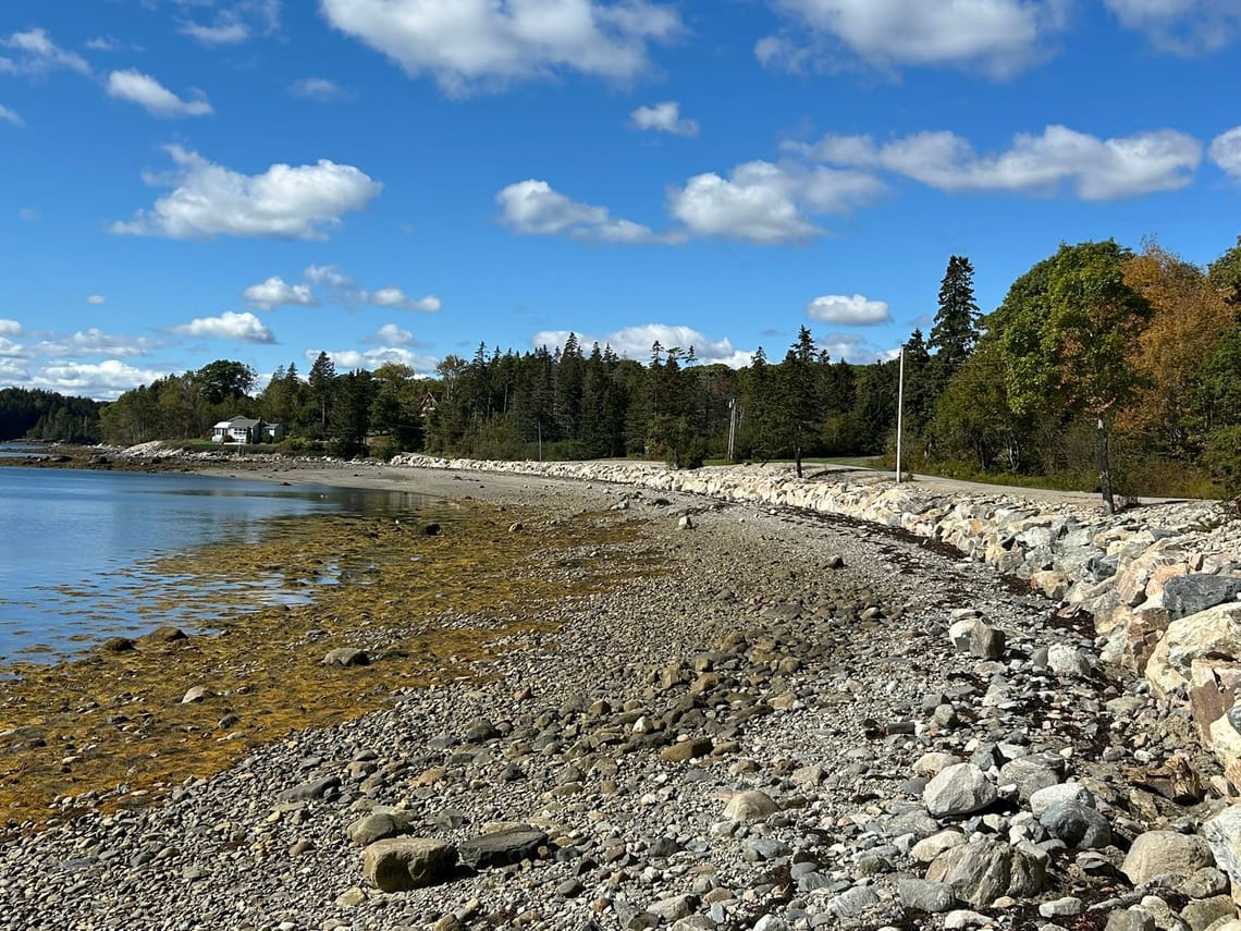
In addition, photographs of a similar riprap revetment project will be presented at the PIC meeting and posted to the project webpage. While every shoreline and project site is unique, these photographs will provide a useful example of the appearance and scale of a completed revetment constructed using similar design principles and materials.
17. How will the design incorporate safe public access to the shore, coves (e.g., Wharf Cove, Spar Cove), and rocks, such as granite steps, pedestrian cut-throughs, or breaks in the wall?
- The design includes dedicated pedestrian access points within Seashore Avenue Areas 1 through 5. These access points will consist of approximately four-foot-wide granite stairways with a handrail that provide access over the revetments and to the shoreline. The intent is to maintain public access to shoreline areas while ensuring the shoreline protection measures continue to function as designed.
18. What percentage of the back shore will become inaccessible, and will the rock surface be smooth and rounded or jagged?
- The project is not intended to eliminate public shoreline access. Residents will continue to have access to shoreline areas outside the project limits, and new access stairways are being incorporated into the revetments to maintain access within the project areas.
The revetments will be constructed using large angular stone. Angular stone is required because it interlocks and provides the stability necessary to withstand wave forces, storm surge, and coastal flooding. While the stone surface will be uneven, the planned access points are intended to provide safe and defined routes across the shoreline protection structures.
19. How far from the edge of the roadway does the riprap begin, and will there be space and a detailed plan to reestablish native vegetation along Seashore Avenue?
- The design is currently being refined to provide a minimum five-foot-wide area between the edge of pavement and the start of the revetment wherever feasible. This area is intended to accommodate an approximately two-foot-wide roadway shoulder and an additional three-foot-wide buffer that can be used for vegetation replacement where construction impacts occur.
Where feasible, existing vegetation will be preserved during construction. In locations where vegetation must be removed to accommodate roadway repairs or revetment construction, replacement plantings will be provided. Replacement vegetation will be installed based on the area of vegetation impacted. While the three-foot-wide buffer area may be used for replacement plantings where needed, vegetation will be restored only in locations where existing vegetation is impacted and where site conditions are suitable for successful reestablishment. This approach maintains the existing vegetative character of the corridor while accommodating the shoreline protection improvements.
20. Will the project maintain the existing parking spaces and vehicle pull-offs along the shoreline?
- Yes. The project is not expected to result in any permanent loss of identified parking areas or vehicle pull-offs along Seashore Avenue. In response to public feedback, the revetment alignment in Seashore Avenue Area 2 has been adjusted to provide additional space between the roadway and shoreline protection improvements, creating additional flexibility for vehicle and golf cart parking in that area.
Construction Logistics, Costs, and Maintenance
21. What is the total cost breakdown for materials, staff time, and soft costs, and is the estimated budget sufficient to implement a project of this complexity?
- The total project budget is $6,009,458, funded through a combination of FEMA (75%), MEMA (15%), and City of Portland (10%) contributions. Of this total, approximately $5.24 million is allocated for repair of storm-damaged infrastructure and $774,163 is allocated for mitigation measures intended to improve resilience to future storm events.
The project budget includes construction costs, engineering and design services, construction administration, permitting and regulatory compliance, and other project-related expenses. The design has been developed to fit within the approved funding framework and will be competitively bid to verify construction costs before work begins.
22. Will the construction bids be itemized, and will the roadway repair budget be used for the revetment?
- Yes. The construction documents will include bid items for the major components of work, including roadway repairs, drainage improvements, shoreline stabilization measures, and other project elements. The project is funded through FEMA-approved repair and mitigation funding. Roadway and revetment improvements are complementary components of the overall project, both intended to protect and restore damaged public infrastructure. Project funds will be utilized in accordance with the approved project scope and funding requirements.
23. How will the significant volume of excavated spoil be handled—will it be transported off-island or dumped on the island, and if so, where?
- Final construction means and methods will be determined by the contractor; however, excavated materials will be managed in accordance with applicable regulations, project specifications, and standard municipal construction practices. Where feasible, suitable materials may be reused within the project limits. Materials that cannot be reused will be transported and disposed of at approved locations selected by the contractor. No decision has been made to establish permanent stockpile or disposal areas on Peaks Island as part of this project.
24. What is the financial plan and equipment strategy for long-term maintenance when massive revetment stones are dislodged by future storms?
- The revetments have been designed using site-specific coastal engineering analyses to minimize the likelihood of stone displacement during future storm events. The proposed armor stone is significantly larger than many existing shoreline protection features, weighing 8,000 to 16,000 pounds, and is intended to withstand anticipated wave forces and buoyancy conditions.
While the revetments are designed to remain stable during typical storm conditions, no shoreline protection system can completely eliminate risk during extreme weather events. Under rare circumstances involving exceptionally severe storm conditions, it is possible that individual armor stones could shift or become displaced.
Following project completion, inspection and maintenance of the shoreline protection system will become part of the City's ongoing infrastructure maintenance responsibilities. If future storms result in isolated stone displacement, the City’s Public Works Department would evaluate the damage and make repairs as necessary to restore the revetment's intended function. As with other public infrastructure, larger repairs would be evaluated based on the extent of the damage and available funding sources at that time.
25. How will construction noise, staging, and heavy truck traffic be managed on narrow island roads, and what is the anticipated construction schedule by area?
- The project is currently in final design and is anticipated to be advertised for bids during the winter of 2026-2027, with construction anticipated to occur in 2027. The contractor will be required to submit traffic control, staging, and construction management plans prior to beginning work. These plans will address construction vehicle routing, material deliveries, work hours, temporary traffic impacts, and other measures intended to minimize disruption to residents, businesses, and visitors.
To reduce impacts during the Island's busiest tourism season, construction activities will be limited between June 15 and Labor Day. This seasonal limitation is intended to minimize disruption to residents, visitors, local businesses, and transportation operations during the peak summer months.
Additional information regarding sequencing and schedule by project area will be available once a contractor has been selected and a detailed construction schedule has been finalized.
26. Has the City evaluated the economic impact of the proposed construction and altered backshore experience on local tourism, rentals, and island businesses?
- The primary purpose of the project is to repair and protect public infrastructure damaged during the January 2024 storm events and improve the resilience of those facilities to future storms. Protecting Seashore Avenue and Long Point Road helps maintain public access, emergency access, transportation connectivity, and access to homes, businesses, and recreational areas that support the Island community and economy.
The City has not completed a formal economic impact analysis evaluating potential effects on tourism, short-term rentals, or local businesses. However, in response to public feedback, the City has revised the design to reduce revetment heights, maintain parking, preserve shoreline access, and replace impacted vegetation where feasible. These refinements are intended to balance infrastructure protection with the character, views, and visitor experience that residents and visitors value.
Process, Permitting, and Community Input
27. Why has meaningful public input occurred so late in the process, and will the City commit to pausing the project to reevaluate options based on community feedback?
- The project timeline has largely been driven by the FEMA disaster recovery process, including damage assessments, funding approvals, engineering evaluations, and development of an eligible repair and mitigation scope. Once a design was prepared, the City conducted presentations to the Peaks Island Council, attended a site visit with the Peaks Island Council and residents, established a project webpage, and provided an opportunity for written public comments.
Community feedback has directly influenced the project, including revisions to revetment heights, shoreline access features, parking accommodations, and vegetation replacement measures. The City is currently incorporating these changes into the design and will present the revised plans at an upcoming Peaks Island Council meeting.
28. Which specific state, federal, and local approvals (including Maine DEP and U.S. Army Corps of Engineers) are required, and where can the public review them?
- The project has received an exemption from the Maine Department of Environmental Protection's Natural Resources Protection Act (NRPA) permitting process because it qualifies as an eligible public infrastructure repair project that meets the criteria established by the State for exemption.
A U.S. Army Corps of Engineers permit is not required because the project does not include work below the waterline or within navigable waters subject to Corps jurisdiction.
The project is also exempt from the City of Portland Site Plan Review process because shoreline stabilization projects of this type are not subject to Site Plan Review requirements.
The local approvals anticipated for the project are Shoreland Zone and Flood Hazard Development permits. Permit applications are expected to be submitted this fall.
29. How will the proposed revetments in Areas 3 and 4 comply with the Peaks Island Land Preserve (PILP) conservation easements, which prohibit structures and protect natural systems?
- The project has been designed to remain within the City's existing right-of-way and areas where the City has authority to maintain and protect public infrastructure. The purpose of the project is to repair and protect existing public roads that were damaged during the January 2024 storm events.
The City is aware of the conservation easements associated with portions of the surrounding property and has considered those constraints during design. The design team met with PILP in September 2026, providing them the opportunity to understand the project and provide feedback. The proposed revetments are located immediately adjacent to existing public infrastructure and are intended to stabilize and protect that infrastructure rather than expand development into currently undeveloped areas. The City will continue coordinating with relevant stakeholders as the project advances toward construction.
30. Who is the City Official in charge of this project, and what is the process for submitting complaints or rejecting the proposal?
- The project is managed by the City of Portland Public Works Department. Contact information for the Public Works Department has been updated on the City website. Project information, project documents, and opportunities to submit comments are available on the project webpage.
31. Are additional FEMA extensions possible to allow for adequate engineering, environmental review, and community engagement?
- Project schedules and deadlines are established through FEMA's Public Assistance program and associated grant requirements. The current schedule anticipates bidding the project during the winter of 2026-2027 and completing construction before the current FEMA project completion deadline of December 31, 2027. While FEMA does have procedures for considering extensions under certain circumstances, there is no guarantee that an extension would be approved. The City is therefore proceeding with final design, public engagement, and permitting activities in a manner intended to meet the current project schedule while incorporating community feedback where feasible.
32. Can the community choose to reject parts of the plan or the entire revetment proposal without losing the FEMA funds allocated for the base road repair?
- The FEMA funding associated with this project is based on a specific scope of work developed to repair and protect public infrastructure damaged during the January 2024 storm events. Significant modifications to that approved scope could require additional review and approval by FEMA and MEMA and could affect project funding eligibility.
The City has worked to incorporate community feedback and refine the project while maintaining compliance with the approved funding framework. The goal is to deliver a project that protects critical public infrastructure, remains eligible for FEMA funding, and addresses community concerns to the greatest extent practicable.
Updates
Question & Comments
Please use the below link to submit questions and comments you have regarding the project. We will endeavor to respond to the questions and comments submitted here prior to the November 2026 Peaks Island Council Meeting
Project Timeline
Storm Damage
FEMA/MEMA Site visits and damage evaluation
Contact Us
Project Manager
Project Location Map
Peaks Island Project Locations
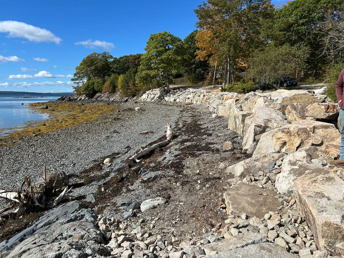
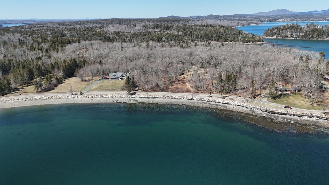
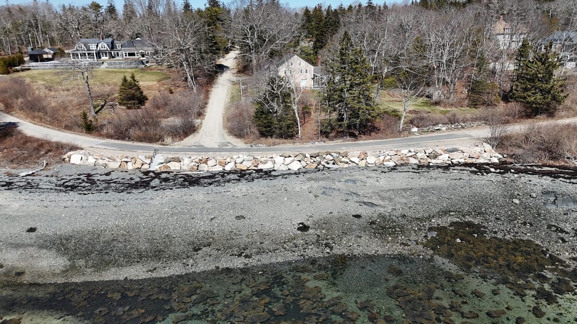
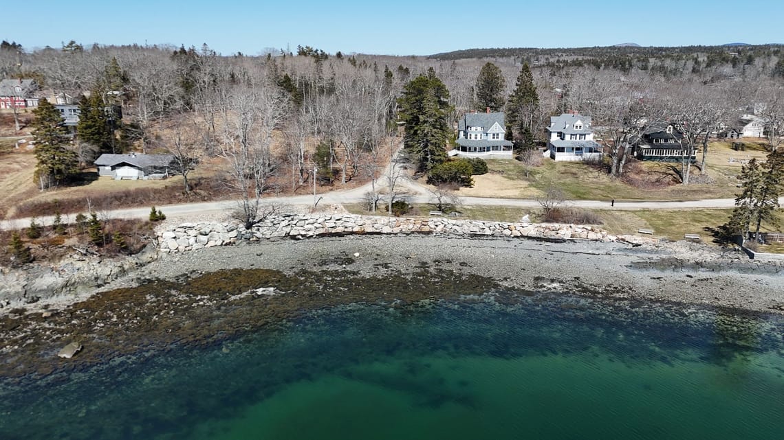
Revetment Example Photos
Below are images from projects in Maine of similar size and scope to the proposed Peaks Island shoreline stabilization project.
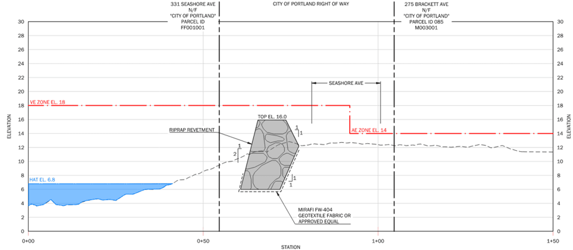
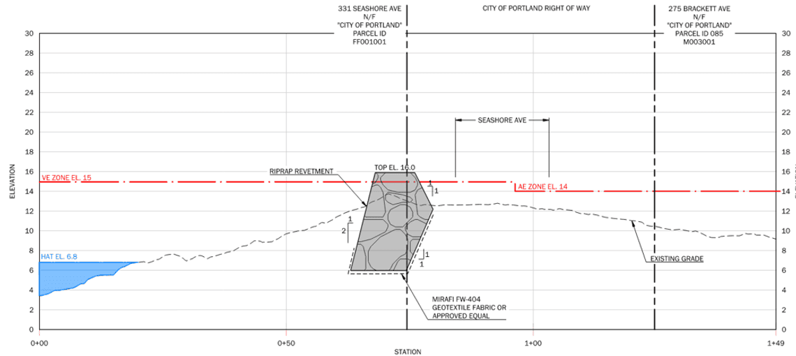
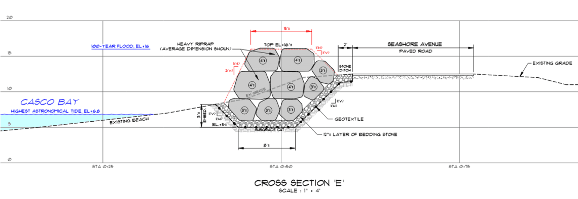
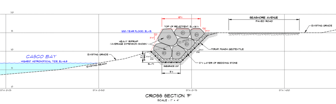
Preliminary Design Cross Sections
These Cross Sections are in the process of being updated and revised will be uploaded here.