
Proposed East Development Area Secondary Plan/Closure of Whitton Road at O'Brien Road
Study Area Map - Town of Renfrew
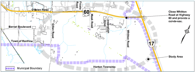
The Town of Renfrew (Town) retained BT Engineering Inc. (BTE) to complete a study that satisfies the Environmental Assessment Act (EAA) and Planning Act requirements for two projects:
- The Renfrew East Development Lands road network; and
- The closure of the Whitton Road leg at O’Brien Road/Highway 60/Whitton Road intersection.
A Schedule C Municipal Class Environmental Assessment (EA) for the closure of Whitton Road at O’Brien Road (Highway 60) was initiated due to the intersection's proximity to the future Highway 17/ O’Brien Road interchange. The EA was completed in parallel with the Master Transportation Plan (MTP) and defines the impacts of the closure and an alternative solution for drivers travelling on Whitton Road to access O’Brien Road through the East Development Lands. The study was completed in accordance with the Municipal Class EA (2023) process under the EAA and the Planning Act.
The Study Area is located in the Town of Renfrew and is bounded by O’Brien Road (Highway 60) to the north, Highway 17 to the east, the Town boundary to the south and Gillan Road to the west.
This Study was completed using the Integrated Approach to simultaneously complete the land use planning for the Renfrew East Development Lands under the Planning Act and the Whitton Road Closure under the Municipal Class EA (2023). The Integrated Approach provided the Town with an opportunity to reduce duplication by simultaneously complying with the Planning Act and the Municipal Class EA processes, including public and stakeholder notification, preparation of technical reports and analyses, and land use planning and environmental protection decisions.
For the full report, please see: Full Report
For appendices, please see: Appendices
Stay Informed
Get notified on upcoming engagements and the latest project related news.