

You Said, We Did : St John's Wood to Marylebone
Consultation Complete: Read about the proposals for Section A and B, consulted on in 2023.
Cycleway 51 - Kilburn to Marylebone.
You Said, We Did: St John’s Wood to Marylebone Cycleway (C51)
Introduction
Westminster City Council, in partnership with Transport for London (TfL), is proposing to deliver a new cycle route, Cycleway 51, connecting St John’s Wood with Marylebone. The proposed route is part of the Westminster Cycle Route Programme and would become part of the London wide Cycleway Network (previously known as Cycle Superhighways and Quietways).
The roads (which we refer to as “the route”) which the proposed cycleway takes were consulted on in 2016 and approved by Cabinet Member in the previous administration in 2021. These proposals outline our updated on-street proposals which have been updated to reflect the latest national guidance and recent traffic conditions. In September-October 2023 we asked for your views on the updated proposals during this initial design stage to refine and improve them further.
The scheme aims to enhance cycle safety and connectivity between St John’s Wood and Marylebone and will benefit all people who want to walk and cycle in the area, particularly those wishing to avoid some of the busier, highly trafficked main roads. Improvements along the route will include:
Improvement of cycle facilities;
Introduction of traffic calming features;
Reallocation of parking to make the route safer;
Clear wayfinding cycleway signage;
Shortened pedestrian crossing points;
Wider and less cluttered footways;
Additional trees and benches
Consultation Results
Please find the information below presented at the 2023 consultation on Section A and B.
Proposals
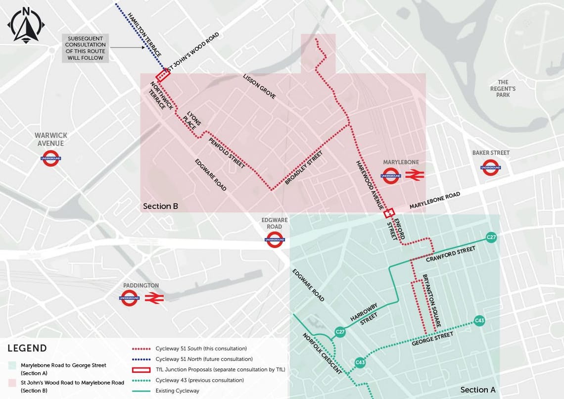
Route: The proposed cycle route includes several roads with features to improve cyclist wayfinding and safety.
These roads are St John’s Wood Road, Northwick Terrace, Aberdeen Place, Lyons Place, Orchard Street, Penfold Street, Broadley Street, Broadley Terrace, Lilestone Street, Treshman Crescent, Swain Street, Casey Close, Harewood Avenue, Enford Street, York Street, Upper Montague Street, Crawford Street, Wyndham Place and Bryanston Square.
The Proposals
The proposals aim to establish a comprehensive and safer cycling network within the area, ensuring convenience and safety for cyclists throughout their journey. Detailed below is a description of the proposed C51 cycle route.
C51 proposal
- St John's Wood Road - A two-way cycle track is proposed between Hamilton Terrace and Northwick Terrace, as well as a parallel crossing at the junction with Hamilton Terrace, and a raised table with clear cycle signage at Northwick Terrace junction. See https://haveyoursay.tfl.gov.uk/c51#2.
- Northwick Place and Lyons Place Cycle wayfinding are proposed along both roads.
- Lyons Place and Northwick Terrace Junction – The junction will comprise a widened footway, enhancing safety for cyclists and pedestrians.
- Aberdeen Place - Cyclist wayfinding to Victoria Passage will create improved connections for cyclists to the canal.
- Orchardson Street - traffic direction will change to one-way southbound only for general traffic between Lyons Place and Fisherton Street, accompanied by a northbound contraflow cycle lane, allowing cyclists to travel in both directions.
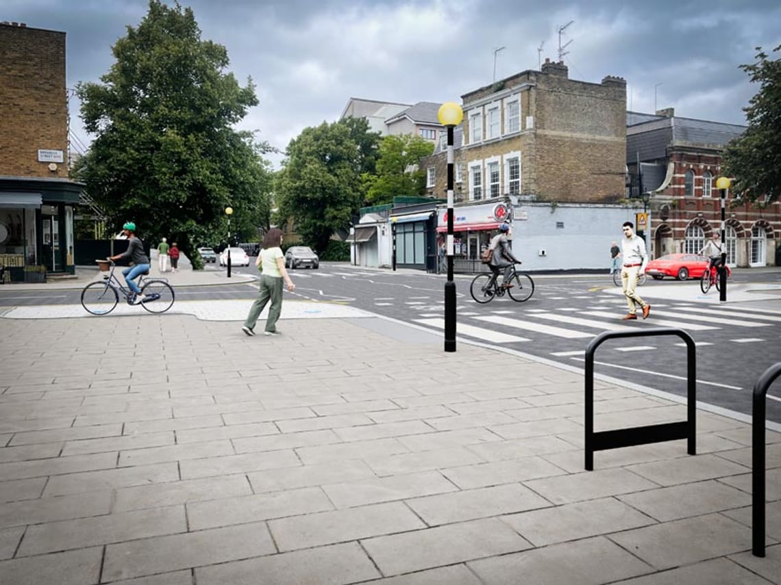
- Penfold Street - traffic direction between Orchardson Street and Frampton Street will change to one-way westbound for general traffic, accompanied by an eastbound contraflow cycle lane. The junction with Frampton Street will have footway widening, cycle wayfinding, and a raised table.
- Penfold Street - traffic direction will remain two-way between Frampton Street and Broadley Street, with clear wayfinding and a raised zebra crossing at the junction with Boscobel Street.
- Broadley Street - Several changes are proposed, including a contraflow cycle lane, pavement widening, and a parallel zebra crossing at the junction with Lisson Grove. Resident parking spaces will be adjusted to facilitate cyclist continuity.
- Broadley Terrace – This section will be made one-way northbound for general traffic, featuring a contraflow cyclist provision. Pavement widening and a new parallel zebra crossing at the junction with Lisson Grove and Broadley Street are planned.
- Casey Close, Swan Street and Tresham Crescent - cyclist wayfinding is proposed to guide users to the Regent’s Canal.
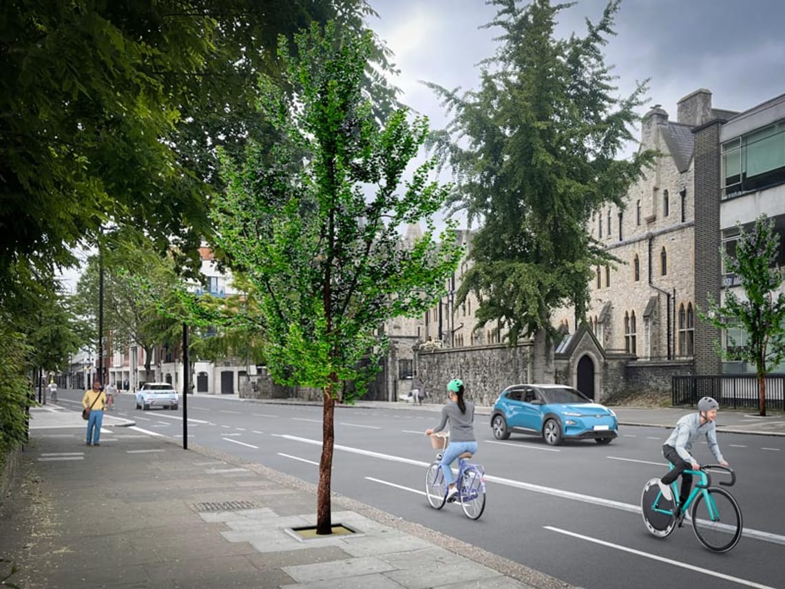
- Harewood Avenue - A two-way protected cycle track will be introduced between Broadley Terrace and Hayes Place. This section will also include widened pavements and raised tables across side roads. Existing zebra crossings will be upgraded, and a new parallel crossing is planned at the rear of Marylebone Station.
- Harewood Avenue - To implement cycleway improvements along Harewood Avenue this will require the removal of 82m of resident car parking and 2 car club parking spaces on the east kerbside between Broadley Terrace and Hayes Place. Additionally, 2 car club spaces near Waterdale Manor House will be removed, along with the removal of 7 pay and park spaces outside 1 Harewood Avenue.
- Harewood Avenue - The section between Harewood Row and Marylebone Road will have a new southbound cycle lane and a segregated northbound cycle lane. A new loading bay will replace 7 pay to park parking spaces, with hospital parking spaces relocated.
- Harewood Avenue - The proposals for Harewood Avenue include the planting of 7 new trees.
- Harewood Row and Hayes Place - Traffic flow on these two roads will be redirected, rerouting buses from Harewood Avenue to Harewood Row and Hayes Place to alleviate congestion on Harewood Avenue.
- The Marylebone intersection – see https://haveyoursay.tfl.gov.uk/c51#2
- Enford Street - Cyclists will have a new southbound option via a contraflow cycle lane, complemented by updated wayfinding and signage.
- Wyndham Place - An alternate cycle route is proposed to guide cyclists through the Wyndham Place public space area, connecting to Cycleway 27 on Crawford Street.
- York Street, Upper Montague Street, Crawford Street, Wyndham Place, and Bryanston Square – Cycle wayfinding and signage are proposed to enhance the cycling experience.
- Crawford Street and Wyndham Place junction - Improvements will be made at the junction, including a widened pavement and a raised table.
- Bryanston Square - will feature cycle wayfinding and a raised table to improve traffic calming and access to the square.
Next Steps
Review the feedback received from St John’s Wood to Marylebone Cycleway questionnaire (Autumn 2023)
Submit updated proposals to Westminster City Council Cabinet Member for City Management and Air Quality for approval (Autumn 2023)
Subject to approval: hold a Traffic Management Order Consultation (Early 2024)
Subject to cabinet members’ approval: delivery commences (Mid 2024)
Frequently Asked Questions
Answers to the most common questions can be found below:
Discover more
Stay Informed
Follow our projects to get notified of upcoming engagements and the latest project related news.