
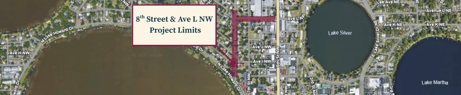
8th Street NW & Ave L NW Project
Updated: October 8, 2026
Project Status: Surveying and Community Input
No roadway design has been developed or selected. The City is gathering information and resident input before preliminary design options are created.
The City of Winter Haven is beginning the design process for potential improvements along 8th Street NW and Avenue L NW. The goal is to evaluate the corridor as a whole, considering roadway conditions, traffic calming, pedestrian and bicycle connectivity, intersection safety, and necessary water and wastewater infrastructure improvements.
We recognize that residents have different perspectives about what improvements are needed and how potential changes could affect the neighborhood. Some have expressed concerns about speeding and pedestrian safety, while others have raised questions about sidewalks, landscaping, and preserving the neighborhood's character.
We want to hear from you before design options are developed.
Get Involved
Tell us how you use the corridor, what concerns you have, and what you believe should be considered as the project moves forward. Survey responses will be shared with the project and engineering team as they begin developing preliminary design options.
Project Updates
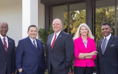
Pwen Ajanda Reyinyon Komisyon Vil la ak Mizajou ki gen rapò ak sa (Pwojè 8th Street NW ak Ave L NW)
Mizajou sou demann sitwayen yo pou yon pwen sou ajanda a ak reyinyon avèk Komisyonè Vil la.
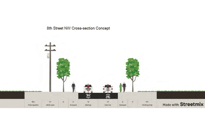
Klarifikasyon enpòtan: Pa gen okenn konsepsyon ki te kreye
Yon desen preliminè ki te enkli nan aplikasyon sibvansyon orijinal Vil la ap sikile e li soulve kesyon. Se pa yon konsepsyon enjenyè, yon plan apwouve, oswa yon reprezantasyon plan.
What Improvements Are Being Considered?
Potential improvements include:
- Roadway resurfacing and pavement improvements
- Traffic calming measures intended to address vehicle speeds and reduce cut-through traffic
- Sidewalks and pedestrian connectivity
- Bicycle connectivity
- Pedestrian crossings and intersection safety
- Drainage improvements where needed
- Coordinated water and wastewater infrastructure improvements
The project generally includes 8th Street NW from Lake Howard Drive to Mirror Terrace NW, along with Avenue L NW extending east from 8th Street toward US Highway 17. The precise limits of individual improvements will be determined through the design process.
The specific locations, dimensions, and configurations of roadway improvements have not been finalized. The project does not propose widening the roadway. The design process will evaluate how improvements can be accommodated within the existing public right-of-way.
How Is the Project Funded?
The City secured a $1,256,720 transportation grant for roadway construction improvements.
The project was ranked No. 1 on the Polk Transportation Planning Organization's 2025 list of Complete Street and multi-use trail priorities. The Polk TPO is the regional organization responsible for coordinating transportation planning and establishing transportation improvement priorities throughout Polk County.
The grant is designated for transportation improvements associated with this project. The City is funding design services through its Transportation Fund and is responsible for construction expenses exceeding the grant award.
Necessary water and wastewater infrastructure work will be funded separately through the City's Water Utility Fund.
Why coordinate the water infrastructure and roadway projects?
Water and wastewater infrastructure improvements are needed along the corridor and will move forward independently of the roadway improvement project.
If the roadway improvement project does not move forward, the pavement disturbed during utility construction would be patched and restored.
Coordinating utility construction with the grant-funded roadway project provides an opportunity to make more comprehensive improvements, including resurfacing the roadway and addressing traffic calming, pedestrian safety, and other identified needs.
This follows the City's "dig once" approach, coordinating infrastructure investments whenever possible to reduce repeated disruption and make better use of available funding.
What Is Happening Right Now?
Updated October 8, 2026
Crews are gathering information and surveying the corridor to accurately identify property and public right-of-way boundaries, existing utilities, roadway features, and other conditions that the engineering team must understand before preparing design alternatives.
You may notice temporary survey stakes, flags, or other markers in the area. These are survey markers, not construction markers. Their placement does not indicate where a sidewalk, curb, or other improvement will be built.
Please leave all survey markers undisturbed. Removing or relocating them requires additional survey work, increases project costs, and delays the development of design options for public review.
How Will Community Input Be Used?
Community participation will take place at several points during the design process.
Before preliminary design: Residents can complete the community survey to share existing conditions, priorities, and concerns. Results will be provided to the project design team.
During preliminary design: The City and its engineering consultant will evaluate alternatives for the corridor, taking into account survey findings, engineering requirements, available funding, and community input.
At the community meeting: Residents will be able to review preliminary concepts, ask questions, and share feedback directly with the project team. A virtual participation option is also planned.
Following the meeting: Residents will have an additional two weeks to review the materials and provide written comments.
As the design progresses: The City will continue providing project information and updates through this webpage and its project notification system.
Community feedback is an important part of the decision-making process. It will be considered alongside safety, engineering feasibility, available funding, and applicable project requirements.
Frequently Asked Questions
Has the City already decided what 8th Street will look like?
No. The City has authorized the evaluation and design process, but no engineered roadway design has been created or selected.
Is the drawing from the grant application the proposed design?
No. It is a preliminary illustration created for the grant application to demonstrate what could potentially fit within the public right-of-way. It is not an engineered roadway plan.
Are sidewalks going to be installed on both sides of the street?
Pedestrian connectivity is one of the project's objectives, and the original grant application identified sidewalks on both sides as a possible improvement. However, actual sidewalk locations and configurations have not been determined. Those details will be evaluated during design.
Will the roadway be widened?
No widening is planned. The engineering team will evaluate improvements within the existing right-of-way, including potential traffic calming features.
Will the project affect trees, landscaping, or the character of the neighborhood?
Those are important considerations in the design process. The existing public right-of-way can extend beyond the paved roadway into areas maintained as lawn or landscaping. The survey will establish accurate boundaries, and potential impacts will be evaluated as design alternatives are developed.
Will the water and wastewater work happen if the roadway project does not proceed?
Yes. The needed utility infrastructure improvements are independent of the decision regarding broader roadway improvements.
When will residents see actual designs?
The City is targeting late 2026 for preliminary design alternatives and anticipates holding a community meeting in December, depending on the completion of survey work. The meeting date and materials will be posted here, and notices will be mailed to nearby residents.
Sign Up for Project Updates
Subscribe to receive notifications about public meetings, design alternatives, opportunities to provide feedback, construction schedules, road closures, and other important project information.
Questions About the Project?
Tyler Williams, Capital Projects & Strategic Initiatives Manager
Key Dates
Community Survey Closes
The purpose of this community survey is to collect input from residents prior to beginning the development of any design options. The community survey will remain open through October 31, 2026. At that time it will close and all results will be publicly available, provided to the City Commission, and provided to the full design team to be incorporated into design development.
City Commission Agenda Item
The community survey results will be shared with the public and City Commission. Public comment opportunity will follow the presentation.
Meeting Details:
- Monday, November 9, 2026
- 6:00 p.m.
- John Fuller Auditorium in City Hall (451 3rd Street NW; The entrance is on the 4th Street side of the building.)
TENTATIVE DATE: Community Meeting – Early Design Input Opportunity
Staff will share early design concepts that will be developed based on input from the community survey. At the meeting we will gather community feedback and input on design concepts. Opportunities to provide feedback on these initial design concepts will also be available on the project page in case anyone cannot attend the meeting or think of things to share after the meeting. The input window will remain open for two weeks following the community meeting.
Project Timeline
Dates are anticipated and may be adjusted as the project progresses.